Tuesday, March 12, 2024
Sunday, April 25, 2010
Background
Besides reading what I've written, you can also:
* CLICK on an entry on the list at right to go directly to that subject.
* CLICK on the red websites in the narrative for more information.
* COMMENT... by phone (207-352-7064), visit, paper mail or email is invited.
You can leave a comment at the end of any segment, like this one: click on the slanted pencil.
* ENLARGE A PHOTO... Just click on it.
The fake date on each segment is to force the 13 chapters or segments to be in the order shown.
You can read this whole blog by just scrolling down, or go to a particular chapter by clicking on it in the list at right.
You can read some of my other travel blogs by clicking on:
DresellySail.blogspot.com
DresellyUshuaia.blogspot.com
DresellyLabrador.blogspot.com
Dreselly.blogspot.com
Dick Dreselly, South Portland, Maine
Friday, April 23, 2010
Beginnings 1931 - 1944
When once you have tasted flight, you will forever walk with your eyes turned skyward, for there you have been, and there you will always long to return".
Leonardo da VinciI'll never forget the evening of November 23, 1931, when I was almost 7. That was a lot closer to the presidency of Abraham Lincoln than to that of Barack Obama, only a generation after the Wright Brothers first flew, and 3 years after Charles Lindbergh turned the eyes of the world skyward with his solo flight from New York to Paris. So perhaps my favorite comic strip then was Buck Rogers, in which space ships traversed the heavens. That evening my parents stopped our car and woke me. We got out to watch in wonder at the apparent space ship just above us. A huge dark cloud obscuring the moon and some stars, it was outlined by white and red and green lights, and accompanied by the thrumming of 8 motors as it slowly passed about 400 feet above us. It could fly that low because there were no TV tower obstructions then. As newspapers reported the next morning, the apparition was the Navy's USS Akron (ZRS-4) (click), then the largest of the world's several dirigibles. It could retrieve, launch and store 5 small planes, and had a range of over ten thousand miles.
 |
Actually the eyes of small boys and adults alike were turned skyward whenever an airplane was seen above. Accounts of daring aviators distracted adults from the Great Depression, and we boys built model airplanes from balsa wood and tissue paper.
In 1941 I bought the first REAL airplane I ever saw for sale, a tiny Aeronca C2 with tattered fabric, displayed on a lawn. I could afford the $300 price because I had graduated from delivering newspapers for a penny each to a $75-a-week night-shift job while I attended full-time high school, building Liberty Ships for the coming War. I was 16, but met the minimum age of 18 by lying about it. I sold the craft two years later, and never flew in a small plane as pilot or passenger until 1950.
In all the accounts below, distances are in statute miles and speeds in statute miles per hour. That was current in 1950, but now nautical miles are standard. Vintage instruments and modern aircraft instruments show that calibration difference.
Segment headings below, like "Beechcraft Musketeer", refer to planes I've owned or others I borrowed or rented that were particularly important to me. Those mentioned but without headings, that I've owned or rented or borrowed briefly, and piloted or co-piloted are: Piper C-2, Ryan Navion, Piper Cubs on wheels and floats, Cessna 140 on skis, Pitts Special, Bushmaster (clone of the Ford Trimotor).
Wednesday, April 21, 2010
Cessna 140 and First 170A
In the spring of 1950 I learned to fly, courtesy of the GI Bill, a government schooling subsidy for those who had been in uniform in the recent War. For each lesson my young instructor, Roger Atwood, would fly his nearly new 2-seat Cessna 140, registered as NC2189V, up from Northhampton to a tractor path in a corn field near where I lived and worked for a non-profit youth travel organization in Northfield, Massachusetts. My lessons were ecstasy alternating with despair. I loved flying, but it seemed Roger was constantly reminding me that I was OK in one dimension while courting disaster in the other two. However, after almost 8 hours of instruction I was launched on my first solo flight. Takeoff and cruise are simple, I thought, but I could wreck the plane on landing. That first flight was supposed to last just a few minutes, but it was suddenly acutely clear that nobody could help me, and I could delay the landing only until the two gas tanks were empty. So I landed. It was the best landing I would make for quite a while, as first solo landings are reputed to be.
My instructor was Robert Atwood, whom you'll see below when Marge and I flew a Cessna 170A to Alaska. Roger was kept as an instructor in WW2 because his teaching skills were so valuable. Among his students were my father-in-law Monroe Smith, then me, and then "Abdullah", a student at nearby Deerfield Academy and future king of Jordan. When Roger died I used channels to tell Abdullah, but received no acknowledgement.
Now I was allowed to risk the airplane and my own neck in solo flight, but the law required I have 33 more hours, alternating with and without the instructor, until I could take up passengers and risk their necks. I was taught new skills, like landing in cross winds and high winds, and flights to other states. I was also taught how to recover from tailspins, which after years of controversy is no longer taught to new pilots. I was taught "pilotage", the deceptively difficult skill of navigating by comparing a map with the view outside the windows, necessary because many planes lacked radios and GPS hadn't been invented. Twenty years later, in 1970, I first flew a plane with a radio, and thirty years after that, in 2000, I first used a GPS.
That Cessna, like most of the planes I've flown since, was a "taildragger", meaning the third wheel to support the plane on the ground is at its tail. The great majority of modern small planes have the third wheel under the nose of the plane, making it easier and safer to land at most airports, but very difficult to land on very rough or soggy fields. So most Alaskan "bush" planes are taildraggers.
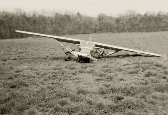
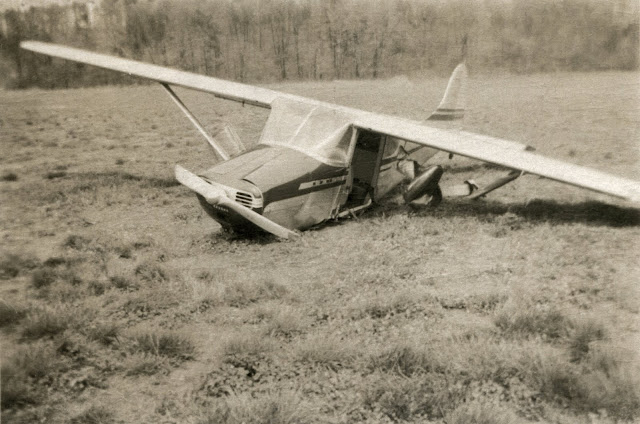
A mere 2 1/2 flying hours after I made that first solo, in the 2-seat Cessna 140, Monroe Smith, my father-in-law at the time, let me solo his nearly new Cessna 170A, registered as NC9115A, which had 4 seats and more horsepower. The previous link shows the small differences between the 170, the 170A and the 170B.
Monroe was an intrepid risk taker, as allowing a very inexperienced pilot to fly his nearly new airplane costing the price of 5 new Fords would indicate. He crashed it that year on a very tight Northfield pasture on which I landed successfully 31 years later in another Cessna 170A.
Roger Atwood took these photos of Monroe's crash, and gave them to me 51 years later, in 2001.
I flew no more until I went to Luxembourg a month later.
Now I was allowed to risk the airplane and my own neck in solo flight, but the law required I have 33 more hours, alternating with and without the instructor, until I could take up passengers and risk their necks. I was taught new skills, like landing in cross winds and high winds, and flights to other states. I was also taught how to recover from tailspins, which after years of controversy is no longer taught to new pilots. I was taught "pilotage", the deceptively difficult skill of navigating by comparing a map with the view outside the windows, necessary because many planes lacked radios and GPS hadn't been invented. Twenty years later, in 1970, I first flew a plane with a radio, and thirty years after that, in 2000, I first used a GPS.
That Cessna, like most of the planes I've flown since, was a "taildragger", meaning the third wheel to support the plane on the ground is at its tail. The great majority of modern small planes have the third wheel under the nose of the plane, making it easier and safer to land at most airports, but very difficult to land on very rough or soggy fields. So most Alaskan "bush" planes are taildraggers.
A mere 2 1/2 flying hours after I made that first solo, in the 2-seat Cessna 140, Monroe Smith, my father-in-law at the time, let me solo his nearly new Cessna 170A, registered as NC9115A, which had 4 seats and more horsepower. The previous link shows the small differences between the 170, the 170A and the 170B.
Monroe was an intrepid risk taker, as allowing a very inexperienced pilot to fly his nearly new airplane costing the price of 5 new Fords would indicate. He crashed it that year on a very tight Northfield pasture on which I landed successfully 31 years later in another Cessna 170A.
Roger Atwood took these photos of Monroe's crash, and gave them to me 51 years later, in 2001.


I flew no more until I went to Luxembourg a month later.
Monday, April 19, 2010
Aeronca Champ: Luxembourg 1950
Below are two accounts of one 1950 incident. I wrote the first from memory when I started this blog about 10 years ago . I wrote the second about 60 years ago, and sold it for $25 to Flying magazine. I lost the Flying issue in which that was published, and for several years searched for it in libraries, airports, and the Internet, without success, until December 2014. When I Googled my name I was amazed that Google Books has put all Flying issues on line, so Google found my name on that article in the May 1956 issue.
My log book shows Luxembourg flights of 0.21, 0.19 and 1.01 hours. My Flying article alters facts slightly, by combining the 0.21 flight and the 1.01 flight, mentioned in the last paragraph of the first account. Otherwise both accounts agree and are true. Each has some details missing in the other.
* * * * * * * * * * * * * * * * * * * * * * * * * * * * * * * * * * * * * * * *
FIRST ACCOUNT:
For two 1950 summer months I was employed by Youth Argosy, a US non-profit travel agency, in Luxembourg, a country 2/3 the area of Rhode Island. I became the only American who had a Luxembourg pilot's license, and may be still.

I found only one small private plane at the Luxembourg city airport, an Aeronca Champ registered as ONT, imported from the USA by the haberdashers guild. Perhaps because our president Harry Truman had been in that profession, perhaps because Americans had liberated their country about 5 years earlier, or perhaps because I had all of 44 1/2 hours in small planes (none after I was awarded my "private pilot ticket"), they allowed me to rent it. In 3 short flights I landed at every airport in the country: all two of them.
For my first of those flights, one pleasant evening I rode my bicycle from my downtown hotel out to the airport to get familiar with this unfamiliar plane nobody had shown me how to fly. After the usual check-up and warm-up I pushed the throttle all the way in, and accelerated down the rough shaggy grass runway for takeoff. As the runway end approached, the plane had not reached flying speed, so I taxied back and tried again where the grass was not as tall. A few seconds after I left the ground a flashing red light appeared in the control tower, the international signal to land immediately. So I made the necessary four right turns, rounded so my path was more like an oval than a rectangle, and came in low on final approach over high tension lines. As I crossed the wires I felt as if some force briefly restrained the plane, but I kept up flying speed by quickly pushing the throttle in and the nose down. I landed smoothly and taxied to where I'd started. I got out to find the cause of the takeoff difficulty and the tower's red light and the odd sensation over the power lines. I found a tangle of wires caught in the braces between the main wheels, with 2 wire strands extending backward. One strand ended about 50 feet back, but the other continued, continued..... I could hardly believe what I found at the end of the wire, like seeing a ghost, so I told nobody about it until Flying magazine published an article I wrote about it. What I saw was that the end of the long wire was nailed to a post. In that entire brief flight I had been tethered like a captive animal. The controller had seen the wires seconds after the plane was airborne, and flashed the red light. He told me that as I crossed the high power lines there was a shower of sparks. Apparently the short wire from my plane caused a short circuit and somewhat resisted the forward motion of the plane. As I biked back to my hotel people were out muttering on their lawns, for I had extinguished all the lights in half the city.
The metered time for all the above was a nominal 0.21 hours or 13 minutes, for engine warming, two takeoff runs, one flight, and taxiing. That confirmed the brevity of the flight.
Much later I made some calculations, and figured that yes, the wire tension could have been just under the breaking point, and the plane could have withstood the pull as if a heavy passenger had occupied the back seat. I wonder what might have happened had the tower not flashed the red light.
I made another flight of 11 minutes there, and a one hour flight to the second airport, a short strip nestled between relatively high buildings in Esch, on the German border, where war damage was still evident. Pilotage (navigating by matching the hand-held map to what I saw below) on this flight was the most difficult I had done before or since, because there were no significant roads, no railroads and no water until I reached the Moselle River at Esch, and mostly a vast irregular patchwork of small multicolored cultivated fields. Not at all like New England.
* * * * * * * * * * * * * * * * * * * * * * * * * * * * * * * * * * * * * * * *
SECOND ACCOUNT:

from HANGAR FLYING in FLYING magazine May 1956


My log book shows Luxembourg flights of 0.21, 0.19 and 1.01 hours. My Flying article alters facts slightly, by combining the 0.21 flight and the 1.01 flight, mentioned in the last paragraph of the first account. Otherwise both accounts agree and are true. Each has some details missing in the other.
* * * * * * * * * * * * * * * * * * * * * * * * * * * * * * * * * * * * * * * *
For two 1950 summer months I was employed by Youth Argosy, a US non-profit travel agency, in Luxembourg, a country 2/3 the area of Rhode Island. I became the only American who had a Luxembourg pilot's license, and may be still.

For my first of those flights, one pleasant evening I rode my bicycle from my downtown hotel out to the airport to get familiar with this unfamiliar plane nobody had shown me how to fly. After the usual check-up and warm-up I pushed the throttle all the way in, and accelerated down the rough shaggy grass runway for takeoff. As the runway end approached, the plane had not reached flying speed, so I taxied back and tried again where the grass was not as tall. A few seconds after I left the ground a flashing red light appeared in the control tower, the international signal to land immediately. So I made the necessary four right turns, rounded so my path was more like an oval than a rectangle, and came in low on final approach over high tension lines. As I crossed the wires I felt as if some force briefly restrained the plane, but I kept up flying speed by quickly pushing the throttle in and the nose down. I landed smoothly and taxied to where I'd started. I got out to find the cause of the takeoff difficulty and the tower's red light and the odd sensation over the power lines. I found a tangle of wires caught in the braces between the main wheels, with 2 wire strands extending backward. One strand ended about 50 feet back, but the other continued, continued..... I could hardly believe what I found at the end of the wire, like seeing a ghost, so I told nobody about it until Flying magazine published an article I wrote about it. What I saw was that the end of the long wire was nailed to a post. In that entire brief flight I had been tethered like a captive animal. The controller had seen the wires seconds after the plane was airborne, and flashed the red light. He told me that as I crossed the high power lines there was a shower of sparks. Apparently the short wire from my plane caused a short circuit and somewhat resisted the forward motion of the plane. As I biked back to my hotel people were out muttering on their lawns, for I had extinguished all the lights in half the city.
The metered time for all the above was a nominal 0.21 hours or 13 minutes, for engine warming, two takeoff runs, one flight, and taxiing. That confirmed the brevity of the flight.
Much later I made some calculations, and figured that yes, the wire tension could have been just under the breaking point, and the plane could have withstood the pull as if a heavy passenger had occupied the back seat. I wonder what might have happened had the tower not flashed the red light.
I made another flight of 11 minutes there, and a one hour flight to the second airport, a short strip nestled between relatively high buildings in Esch, on the German border, where war damage was still evident. Pilotage (navigating by matching the hand-held map to what I saw below) on this flight was the most difficult I had done before or since, because there were no significant roads, no railroads and no water until I reached the Moselle River at Esch, and mostly a vast irregular patchwork of small multicolored cultivated fields. Not at all like New England.
* * * * * * * * * * * * * * * * * * * * * * * * * * * * * * * * * * * * * * * *
SECOND ACCOUNT:
from HANGAR FLYING in FLYING magazine May 1956
WIRED FOR PATTERN
During 1:45 of flight time in the Grand Duchy of Luxeumbourg I landed at every airport in that pint-size prototype of Graustark.
One field was a 1,000 foot corduroy grass strip at Esch. Landing, you graze apartment houses and power lines. Taking off, you bank as your wheels leave the ground, to skirt an old slag heap square in the middle of the runway. Then, after being tossed by hot air from blast furnaces at the end of the field, you bank sharp left to avoid crossing into France. The other field, four miles north of Luxembourg city, is a good paved strip flanked by a grass area for use by the country’s ten or so lightplanes.
After finishing work one night at our office in Luxembourg City, I bicycled out to the latter field. In my pocket was a Luxembourg flight permit (the first issued to an American, they told me), and a US log book with 42 hours therein. Since this time was on Cessnas, the prewar Aeronca I rented for 12 cents a minute added a few dashes of the unknown.
The whole country, plus parts of France, Germany and Belgium, could be seen from 3000 feet. I flew around the city to view the still-standing battlements and precipitous topography that had made Luxembourg one of the most important fortresses of the medieval world. Then I flew out over Hollenfels Castle, perched above a little gorge, with crossbow slits in its ancient gray walls and surmounted by a high round tower.
After leaving the castle and practicing a few turns, I touched down on the field at sunset, but figured there was time enough to shoot one more landing, and shoved the throttle ahead. Strangely, the plane pulled to the right and wouldn’t leave the ground. After 1,000 feet, with a third of the runway left to go, I cut the power and taxied back. A quick glance from the cockpit disclosed no apparent obstruction, and since the sidewise pull had disappeared, I concluded that it had only been grass in my wheels. I tried it again, and this time the ship reluctantly left the ground.
Just as I crossed the end of the field, an insistent red flash from the tower caught my eye. Since it was getting pretty dark and the Aeronca seemed to be carrying some unseen load, I made the briefest pattern I’ve ever flown. On the final approach sluggishness seemed to appear at a higher speed than before. I attributed this to errors in my frantic attempts to convert kilometers-per-hour readings into miles-per-hour. I landed faster but stopped much shorted than usual. Then, even with full left rudder and full throttle, the plane insisted on taxiing in a circle to the right. After some maneuvering, I made it up to the flight line.
Now the field was nearly dark and deserted except for two apparently worried airport employees who came out to meet me. “Did you know you have a long wire trailing in your landing gear?” one asked in French. I should have known! The other explained that the wire had been dragged across the power lines at the end of the field as I came in, thereby extinguishing all the lights in the northwestern sector of Luxembourg. Furthermore, he reported, a motorist passing under the line had been showered by sparks and had come in to find out “if the pilot had survived the crash.”
I still wasn’t prepared for the rat’s nest of wire around the right wheel and some on the left, nor for the bigger surprise to come. While they worked to unravel the wire I followed it back to find out just how long it was. The strand which had apparently dragged over the power line ended 300 feet behind the plane, but the other strand went on and on, past the hangar and down back of a parked D-3. There, believe it or not, the wire was securely fastened to a wood post. I had been tethered like a cow to a pole during that entire last go-around! Feeling like the incredulous yokel who said, “there ain’t no such animal”, I later worked the event out with slide rule and paper. Surprisingly, it figured that with the plane 1,500 feet from the pole and at 500 feet altitude, the wire’s pull on the plane would have been less than 100 pounds. Of course, if I had gone further from the post, the pull would have increased until the wire or the plane gave way.
I expected to lose my license, but the officials blamed it all on the failure of some airport employees to remove a network of wire from the foot-high grass on the airstrip.
RICHARD DRESELLY
New York, N. Y.
Saturday, April 17, 2010
First Commonwealth Skyranger: 4/1954- 7/1955
My flight log shows a few entries in the Cessna 140 after I returned from Europe, but none for the 34 months after June 1951. During that time I became divorced and was a civil engineer for two seasons in Greenland. There we worked 10 hours a day, 7 days a week, with overtime after 40 hours weekly. IRS laws made those high earnings tax free if the worker was in a foreign country 510 full days out of any 18 month period. That left about 37 days one could spend in the USA or on international waters, so we all would go home briefly and then "abroad" until Metcalf & Eddy called us back to Greenland.

Click: http://www.airbum.com/pireps/PirepSkyranger.html
There were many times, some mentioned below, where it looks like I was pushing the envelope too far. However, I got as comfortable flying the plane as I did a bicycle, there were far fewer other planes in the air to avoid then, and the Skyranger design was exceptionally safe. Commonwealth Aviation was one of several companies that resumed producing planes after the War, to accommodate an anticipated huge market. But production greatly exceeded demand, most small airplane builders went bankrupt, and one could buy a superbly engineered Skyranger for a lot less than it had cost Commonwealth to build it. Almost uniquely it had leading edge slots near the ends of both wings which, as the plane slowed towards its stalling speed of 38 mph, would force air to flow smoothly over part of the wing ends, providing some support, so the plane would "mush" down instead of dropping like a stone as did other planes when stalling. In the picture the slot on the bottom of the near wing appears faintly above "9 7". The Skyranger cruised at 95 mph, but could be flown safely at 45 mph. Flying into the wind on landing yielded a ground speed like that of a vigorously pedalled bicycle.
April 14 I headed for Florida, to visit my daughter and my friendly ex-inlaws. At dusk I landed at Basking Ridge, NJ, where an X at each runway end indicated the field was closed. I slept on the floor of an empty hangar.
The next morning I couldn't start the engine. Since there was nobody else there, I phoned an active airport for help. An affable man arrived, and quickly discovered that I'd forgotten to turn on the magnetos after turning on the main switch. He told me that he couldn't get an airline job in spite of his flying experience in the war in Europe and in the USA, because of the color of his skin. Years later the FAA published a book about that Tuskegee Airman, who died on a humanitarian flight in Africa.
(added 11/4/18: for details see Google: August Martin pilot)
(added 11/4/18: for details see Google: August Martin pilot)
As I approached Washington a black cloud wall ahead forced me to land at the next field. It was Beltsville, a government facility not open to outsiders I was quickly told after landing, but I was allowed to stay 2 hours until the storm passed.
The only air charts (maps) I had been to get in Lewiston ended about where I was, but I continued flying mapless past DC until I could spot an airport. I found one in Virginia, landed, and bought charts for my entire route to Texas. I landed that night in Raleigh, North Carolina.
The only air charts (maps) I had been to get in Lewiston ended about where I was, but I continued flying mapless past DC until I could spot an airport. I found one in Virginia, landed, and bought charts for my entire route to Texas. I landed that night in Raleigh, North Carolina.
The next morning the ceiling (bottom of solid clouds) was less than a thousand feet, so I didn't fly. Then a small Tri-Pacer came in from the south, and out got the pilot, on crutches. Quite illogically, I figured that if he could fly, so could I. So I took off, flying at about 700 foot altitude. However, I found that with no lakes or ocean like in Maine, and without the perspective of ample altitude, I was soon lost. I struggled with the controls and map folds trying to match railroads and towns to what swiftly passed below, but I remained lost, so landed on a newly plowed field. The farmer acted as if my landing was routine, and told me where I was. I got back in, pushed the throttle all the way in, the engine roared, but the plane didn't move. That was because the furrows ran the short way of the field, and the two main wheels were in a furrow. I rocked the elevators back and forth, and the plane struggled out of that furrow, then another, as the bumps got more rapid and lighter. I left the ground and immediately flew between the barn and the house. I wonder what the farmer and his wife thought. The weather improved, and I continued southward by "the other IFR": I Follow Railroad. IFR really means Instrument Flight Rules, flying "in the soup", for which neither I nor my plane were equipped.
Just before sunset that day, April 16 1954, I landed at Savannah, Georgia. My initial IRS ration of 37 days was dwindling, but I couldn't immediately continue, since I'd never flown at night. In a very lucky coincidence, when I paid for gasoline in the airport office I met a crop-duster, D. L. Curry, who had just delivered a plane there and wanted a ride back home. Home was 300 miles south, right beside the people I was to visit in Delray Beach, Florida. So we flew south in darkness in my plane, a few miles inland from the bright lights along the coast. He neither used nor needed a map. Over the dark land west of Delray Beach there was an occasional pinpoint of light. Over one he circled low, throttled back, and shouted "Hey Monroe" out the opened window until more lights appeared below. As we circled, we saw that Monroe drove to the little grass field and directed his car lights down its short length. Landing was a little tricky, because the lights were pointed downwind, towards us. In the picture below, the next day, are Monroe and Isabel Smith and their son Jonathan, with Monroe trying to start the engine by "propping" it. Presumably the brakes were set and I took the picture, which looks unposed. Monroe and Isabel were my friends, the parents of my ex-wife, and the founders of American Youth Hostels. All these stories are in my aircraft log book, but they don't explain why this plane is not bright red in this picture.
Just before sunset that day, April 16 1954, I landed at Savannah, Georgia. My initial IRS ration of 37 days was dwindling, but I couldn't immediately continue, since I'd never flown at night. In a very lucky coincidence, when I paid for gasoline in the airport office I met a crop-duster, D. L. Curry, who had just delivered a plane there and wanted a ride back home. Home was 300 miles south, right beside the people I was to visit in Delray Beach, Florida. So we flew south in darkness in my plane, a few miles inland from the bright lights along the coast. He neither used nor needed a map. Over the dark land west of Delray Beach there was an occasional pinpoint of light. Over one he circled low, throttled back, and shouted "Hey Monroe" out the opened window until more lights appeared below. As we circled, we saw that Monroe drove to the little grass field and directed his car lights down its short length. Landing was a little tricky, because the lights were pointed downwind, towards us. In the picture below, the next day, are Monroe and Isabel Smith and their son Jonathan, with Monroe trying to start the engine by "propping" it. Presumably the brakes were set and I took the picture, which looks unposed. Monroe and Isabel were my friends, the parents of my ex-wife, and the founders of American Youth Hostels. All these stories are in my aircraft log book, but they don't explain why this plane is not bright red in this picture.


The next afternoon I left for Texas, circling the Gulf of Mexico. From Brownsville, where USA and Mexican customs and immigration facilities were conveniently combined, I flew towards La Pesca (The Fish), Mexico, 200 miles south. My chart showed it as a village without an airport at the mouth of a big river, but an article in True Magazine in a single sentence mentioned that there was a rudimentary airstrip there. I flew two hours a few feet above the beach, occasionally looking up at cows on the adjacent fields. I saw not a single person or structure in that time. The photos in this segment are about 62 years old. The beach photo was taken when I ascended a little higher to simultaneously manipulate airplane and camera controls.
 |
| Looking inland. Note muddy river water meeting blue sea water. |
After 2 weeks at the next stop, Tampico, I flew south along the Gulf to Tuxpan. An airline pilot who had just come from Mexico City told me there were big breaks in the overcast, so I could fly up in the clear to continue on top to where Mexico's central plateau penetrated the clouds. I tried that, but the hole was too small and I was immediately in thick cloud with zero visibility. I quickly descended to clear air. After some thought I decided to climb up anyway. I knew if I headed towards the rising ground in the soup, "the earth might rise up to smite me", so I turned left to fly parallel to the jungle wall. Below the clouds I set the plane to a uniform ascent of about 400 feet per minute, which with an expected cloud thickness of a thousand feet, meant I should emerge on top in less than 3 minutes. It was like being in a telephone booth surrounded by brilliant white cotton, which I could see swirling between me and the propeller. After a year-long minute I had a constant dilemma: do I give up and descend swiftly, or am I about to break into sunlight on top, or do I continue climbing but go into a spin? I kept my fingers lightly on the control stick so as not to disturb what the plane was doing so well. Occasionally I glanced at the simple turn-and-bank instrument, which was supposed to tell me if the wings were level. The longer I flew the greater the dilemma, until there was a flash of sunlight as I went through a deep hole in the corrugated cloud surface, confirming that the wings were still level. Soon I was skimming the top. It was one of the most beautiful scenes I have ever seen. I took the above picture then. I felt I was in heaven in body, where three minutes before I might have arrived there in spirit. I never tried that again. Solid white cloud below extended all around, except where higher ground appeared far ahead and the high cones of volcanoes Popocatépetl and Iztaccíhuatl appeared beyond. Navigation was as simple as it gets. I had no radio, the map didn't show any mark of civilization, and soon all was brown below, so I just aimed right of the volcanoes, where I knew the city was.
Mexico City is surrounded by higher ground, so one must ascend to at least 10,000 feet to fly there. I flew beyond the cloud cover, over undulating scrubby vegetation until I could see the Aztec pyramids,


countless swirling dust devils, and some kind of chemical concentration spiral, and the city, with the biggest highest airport I've ever used, at 7300 feet elevation. The air in that central valley was as crystal clear as when Cortez invaded it. Decades after my flight it was rated the most polluted and murky on earth, until Chinese cities became worse. A green light from the tower said it was OK to land on a strip parallel to that used by the international airliners, so I did.
Mexico City is surrounded by higher ground, so one must ascend to at least 10,000 feet to fly there. I flew beyond the cloud cover, over undulating scrubby vegetation until I could see the Aztec pyramids,


 |
| IF SOMEONE KNOWS WHAT THIS SPIRAL DOES, PLEASE LEAVE COMMENT. |
countless swirling dust devils, and some kind of chemical concentration spiral, and the city, with the biggest highest airport I've ever used, at 7300 feet elevation. The air in that central valley was as crystal clear as when Cortez invaded it. Decades after my flight it was rated the most polluted and murky on earth, until Chinese cities became worse. A green light from the tower said it was OK to land on a strip parallel to that used by the international airliners, so I did.

I made three flights to Acapulco. The night club where divers plunge down a cliff to water that is deep enough only when they hit it as a wave comes in is just left of the center of the picture. The divers are as famous as movie stars, and marry them. The picture is restored from my 62-year-old 35 mm slide. I remember romantic evenings with a girlfriend at that night club, watching the divers.

To get to Acapulco I had to cross a higher mountain ridge south of Mexico City, so I learned to find rising air currents, like eagles and glider pilots do. Some of the areas near my route were labelled on a Mexican map as "tierra desconocida", meaning unexplored territory. On the first trip I met a girl, a schoolteacher from Mexico City. That prompted a second trip to Acapulco, on the return from which I was gradually forced upward as the thickening cumulus clouds rose, until the Skyranger was mushing along at 12,600', where one is supposed to use supplementary oxygen. Before I found a descent hole I was threading a path around towering clouds of ethereal beauty, like iridescent white cathedrals.
 |
| Clouds thickening: not many holes left for descending to Earth. |
- High Flight
- Oh! I have slipped the surly bonds of Earth
- And danced the skies on laughter-silvered wings;
- Sunward I’ve climbed, and joined the tumbling mirth
- of sun-split clouds, — and done a hundred things
- You have not dreamed of — wheeled and soared and swung
- High in the sunlit silence. Hov’ring there,
- I’ve chased the shouting wind along, and flung
- My eager craft through footless halls of air....
- Up, up the long, delirious, burning blue
- I’ve topped the wind-swept heights with easy grace.
- Where never lark or even eagle flew —
- And, while with silent lifting mind I’ve trod
- The high untrespassed sanctity of space,
- Put out my hand, and touched the face of God.
I took up smoking 5-cent-a-pack black Mexican cigarettes. I was 29, rather late to begin an addiction that I quit with great difficulty 12 years later.
That may have been why I failed in climbing Orizaba, Mexico's highest volcano at 18,500'. I took a taxi (about 5 USA cents a mile) from Mexico City to the village near its base, Tlachichuca, the driver stopping occasionally to nervously ask someone if there were "bandits still about". My climbing guide had a prominently enlarged chest from breathing the air of his home at 11,000' altitude. We spent the night in a mountain cave at 13,500', the pack horse tethered outside. I had to force each breath until I acclimatized somewhat, and slept. The next morning I laboriously ascended to steep snow at 16,500', where I couldn't take another very slow step upward. I told the guide, "No puedo andar mas" (I can't go further), so we slowly descended.
That may have been why I failed in climbing Orizaba, Mexico's highest volcano at 18,500'. I took a taxi (about 5 USA cents a mile) from Mexico City to the village near its base, Tlachichuca, the driver stopping occasionally to nervously ask someone if there were "bandits still about". My climbing guide had a prominently enlarged chest from breathing the air of his home at 11,000' altitude. We spent the night in a mountain cave at 13,500', the pack horse tethered outside. I had to force each breath until I acclimatized somewhat, and slept. The next morning I laboriously ascended to steep snow at 16,500', where I couldn't take another very slow step upward. I told the guide, "No puedo andar mas" (I can't go further), so we slowly descended.
In Mexico city I logged a few hours in a Link trainer, a pre-computer flight simulator, to develop skill in "blind flying", which is flying with reference only to instruments in the airplane.
On my way back to Maine I flew my longest hop ever, from Nuevo Laredo, Mexico, where I was cleared by Customs of both countries, to Pine Bluff, Arkansas, 642 statute miles at about 10,000' with a tailwind. The official range of the plane was 500 miles. On landing the engine was still running, but both gas tank needles were on E(mpty). My 2 days from Mexico to Maine in a little VFR plane might have been a record. I landed in a pasture near my father's business in Winthrop, and later tried to take off again. However, I forgot that on takeoffs from muddy fields the pilot is supposed to hold the stick way back to keep the tail low until leaving the ground, the opposite of the position for normal takeoffs. As I accelerated to about 25 mph, suddenly the wheels caught in the mud, the tail went up, things cascaded over my shoulders, and the plane came to rest with the bent propeller in the mud.

I returned to my job in Greenland, while the farmer cut the field length in half with a new fence, and cows chewed holes in the plane fabric. One day, I was told, the mud had dried, the holes were patched, the wind was just right, and Bill Perry, the Augusta airport FBO, attached a new prop, squeezed aloft over the fence, and flew to an airport which has since disappeared, South Portland's "Port Of Maine" airport (Google that), near the Rigby "railroad roundhouse". As of June 2024, the roundhouse and airport have been erased.
The next year, 1955, I again went from Greenland to Maine, then by Skyranger to Mexico. Enroute I visited in Geneva NY an engineer friend from Greenland, Paul "PJ" McDonough, as shown in an issue of Geneva Times accessible by Googling my name. Continuing, I buzzed Niagara Falls, which was legal then but not now, and took this photo:

In the evening of May 6 I landed for gasoline in southern Texas as another stack of 37 days was dwindling. I could reach the border at Laredo by 10 PM, but had never soloed in the dark. I figured I'd learn the new skill by just continuing, like learning to swim by jumping off the dock, so I flew into the night. When I got a few miles from the glow of Laredo ahead I searched in vain for where lighted airport runways were supposed to be. There was not even a street light to mitigate the darkness below. So I flew to the Rio Grande, the border with Mexico, its waters visible down but not ahead in the faint moonlight, turned downstream until I found a unique bend shown on the chart, then turned left for what I now calculated was the airport 2 miles ahead. I dimly recall that my altitude was about 500 feet. With the faint moon I couldn't see the airport ahead until at the predicted moment I suddenly saw a runway below, indicating my dead reckoning had been perfect. As I looped around to land I turned on the landing light. It didn't help, but blinded me, so I turned it off, circled away from the unseen hangars ahead, and returned for a landing, very cautiously since I could barely see down, and hardly at all ahead. The hangars were visible only as I passed them. I came to a halt at the very end of the runway. The buildings were locked so there was no phone. I went to the adjacent deserted road, looking for a car that might give me a lift to town. Perhaps 15 minutes later one appeared and slowed. The driver apparently thought better of my outstretched thumb, and started to drive onward. I shouted, "PLEASE SEND TAXI !" The car stopped, and I was invited into the back seat. In the front seats were two older ladies. Between them was propped a large shotgun, pointed just over my head. They said they had been hunting rattlesnakes, which lie on the hot pavement after dark. It was good I hadn't attempted to walk the 5 miles to town.
In Mexico City I found the Navion had been attached and hangared by a business to which Milton owed money. That was illogical and illegal, because he never became my partner, but I struggled with lawyers and courts and corruption to retrieve my Navion. My life was threatened, so my lawyer suggested I change my hotel residence, which I did by walking several blocks in a maze until I was sure nobody was following me. Finally I gave up and flew N92975 back to Maine.
The rainy season had begun, so I flew north across a couple hundred miles of high central plateau under a low overcast, then down through corrugated jungle valleys to Ciudad Victoria for gasoline.
 |
| This exactly matches my vivid memory of the flight in marginal VFR, following valleys from the high tableland down to the lower plains. |
From there on the ground was much lower but the clouds were still at the same high elevation, so pilotage (navigation by comparing the map to the few features on the ground) to Texas became much easier.
I sold the Skyranger in Maine and went to Holland to buy a small sloop, which I eventually sailed back to the USA alone, detailed in DresellySail.blogspot.com
Flying then was a lot cheaper then than now, even allowing for inflation. I figured it cost me about dollar an hour. Five gallons an hour at 16 cents/gallon. Ten cents an hour for oil changes. 10 cents an hour for miscellaneous. Zero for overhauls because I never had any done. Zero for insurance: I had none. Zero for depreciation, since I sold my $800 (tax free) plane for $900 minus a 10% commission: a $10 profit. residents, especially the poor, that we consider it the norm.
PS on 8-16-2015: N92975 is still flying 60 years later, based at West Lafayette, Indiana.
Thursday, April 15, 2010
Mooney Mite and Navion: 1957
While I was sailing, my lawyer had Cantinflas's (click on that) chief pilot take the Navion when nobody was looking, and fly it to the airport at Grand Prarie, Texas. Apparently he could do that because his boss, "the Mexican Bob Hope", had influence and was above the local corruption. By then I had learned that Milton had dropped bombs in a recent war in Guatemala, was wanted for murder there, and was a pederast.
I didn't return to Mexico for several years. However, these and subsequent visits to Mexico left me with a deep respect and affection for its people and culture. That it has some bad dangerous people is obvious. That some of its underpaid police and officials seek bribes in order to support their families
is well known. However I, and later my wife Marge with me, have had so many experiences of kindness, trust and dignity from Mexican residents, especially the poor, that we consider it the norm.
I visited Al Mooney, an iconic designer behind the Mite and other planes, at his small factory in Kerrville, Texas, to ask if the Mite could be retrofitted to carry sufficient gasoline to be flown to Europe via Labrador, Greenland, and Iceland. We sat on the grass and talked about it. After some thought he said yes, but eventually I abandoned the idea.
At 550 pounds empty the Mite was about the lightest manufactured aircraft since the Aeronca C2. It had a single seat, so I would have to teach myself to fly it. Shortly after I took off for the return to Maine I realized I was sitting on the unfastened seat belt. As I raised my hips enough to free the belt, my head bumped the sliding canopy above. That made it fly off and away. The revised air currents slowed my speed by 10 mph, and made the dirt on the floor fly up in my face. There was nothing to hold me in the plane if I were bumped upward in turbulence, so I quickly fastened the belt. I reached Louisville, Kentucky by dark, and found Smitty had delivered a defective plane to me: the lights didn't work. In the landing at Louisville I should have held the nose higher, but the front (tricycle) wheel struck first, and collapsed. I held the nose up as I steered off the runway, ending nose-low and tail-high, as in Winthrop. Like in Winthrop there was no injury except to my pride and pocketbook. I sold the damaged bird to the Louisville FBO, and returned to Maine by commercial plane.
Tuesday, April 13, 2010
Auster and Cessna 120: 1956- 1958
While on the sailboat previously mentioned I visited P.J. Macdonough and his wife in England, where he was working. PJ, a fellow engineer from Greenland, was great as a man, an engineer, and a father, and here in 2014 I miss him. He had been shot down in the War and survived German imprisonment. We rented a little British-made Auster, and flew it across the Channel to France, Belgium and back. I vividly remember the huge horizontal figures south of London made millenia ago by stripping off soil to expose the white chalk that extends to the chalky White Cliffs of Dover.
I bought an Ercoupe in Kilgore, Texas, and flew it to Smitty's operation in Grand Prarie. He swapped it for a Cessna 120 (like a Cessna 140 without flaps), which I flew to Maine in late 1957. I flew it some in Maine, and sold it the next year. I didn't own or pilot a plane again for 7 years.
I bought an Ercoupe in Kilgore, Texas, and flew it to Smitty's operation in Grand Prarie. He swapped it for a Cessna 120 (like a Cessna 140 without flaps), which I flew to Maine in late 1957. I flew it some in Maine, and sold it the next year. I didn't own or pilot a plane again for 7 years.
Sunday, April 11, 2010
Second Commonwealth Skyranger: 7/1965- 6/1966
In Maine in July 1965 I started going with Margery Pierce, and bought another Skyranger, registered as N33385. I flew it for 80 hours, mostly in Maine, until I sold it a year later and went to work as an engineer in Vietnam. My relationship with Margery lasted much longer. We married in 1968, after Vietnam, and are still enjoying life together.
The Skyranger and I were based in Augusta, Maine. Marge lived with her parents and son there too. She and I landed at many little Maine and New Hampshire airports, and several places that weren't airports. We especially enjoyed landing on Seawall Beach, which was then little known and accessible only by taildraggers or a two mile trail.
Beach landings are easy, but require some knowledge and skill. The pilot should land:
* On the strip of hard dark sand between the soft wave-washed sand and the loose dry sand near the high tide mark.
* When the tide is half way out and receding (consult tide tables ahead), to give a wider "runway" and more time for extraction if the wheels get stuck, which should be unlikely.
* When there's nobody on the beach, and it's not nesting season for the endangered piping plovers.
My slightly edited letter of October 31, 1965, Sunday
Dear Margery,
The Skyranger and I were based in Augusta, Maine. Marge lived with her parents and son there too. She and I landed at many little Maine and New Hampshire airports, and several places that weren't airports. We especially enjoyed landing on Seawall Beach, which was then little known and accessible only by taildraggers or a two mile trail.
Beach landings are easy, but require some knowledge and skill. The pilot should land:
* On the strip of hard dark sand between the soft wave-washed sand and the loose dry sand near the high tide mark.
* When the tide is half way out and receding (consult tide tables ahead), to give a wider "runway" and more time for extraction if the wheels get stuck, which should be unlikely.
* When there's nobody on the beach, and it's not nesting season for the endangered piping plovers.

My slightly edited letter of October 31, 1965, Sunday
I think Marge, an R.N., at the Togus veterans hospital, was working that weekend.
We have been married since 1968.
We have been married since 1968.
Dear Margery,
My flight this weekend was my most hair raising in months. After you left I dubbed around, had coffee and donuts. I considered the local Flight Service suggestion that the weather didn't look flyable towards the mountains, but took off to check. Then I realized I'd forgotten my camera, so landed and got it. Continuing, the terrain forced me higher, and the headwind got stronger. Over the low mountains from Conway to Woodstock my ground speed was under 45 mph, so the headwind was about 50. Halfway across the Kancamagus highway clouds in my path drooped down and there was no way around, so I went through. Ground was always visible but such a combination of sleet and turbulence I've never encountered before. I throttled way back to reduce the violent buffeting. Ice grew on the wing leading edges. I was scared, and then I came into the clear again.
I came down from 4500 feet to the Lincoln - North Woodstock airport. It's in a pocket, short, dirt and surrounded by trees. When I landed there was nobody and no planes. I spent a half hour doing things inefficiently. Just as I set foot on the road a lady (60 +) stopped her car for me. She is the wife of the undertaker who is the principal user of the airport. She drove me 5 miles up the Kancamagus road to the trail I wanted. Since the plane is not lockable I left my flight bag with her for safekeeping.
The trail was very wet, then there was snow from last week's storm, which got deeper It was a good day, and the woods were beautiful. The pine needles on the sharp white snow would make a good wallpaper pattern. I hiked 7 1/2 miles up the ridge, a 3300 foot climb, to Mt. Flume then Mt. Liberty (two more 4000+-footers), then Liberty Springs shelter, mostly through 6 inches of snow. Fine views. Wind on the bare summits made me glad I brought lots of warm clothes. Halfway down from the shelter to the road I remembered I left my new ski mittens at the shelter, so I returned. By then it was dark, so I spent the night there, with a bunch of schoolboys and their leader. I slept with parka, heavy wool pants, long johns, and mittens, but woke up chilly a few times.
This morning I rose at dawn, skipped eating, and took an hour to reach the highway. There was a little rain and worsening weather, so it sure looked like I'd have to leave the plane and return home otherwise. I hitch hiked to North Woodstock, ate, and phoned Mrs. McKay. She insisted on bringing up the bag and driving me to the plane. Much of the hills were in rain, fog, cloud, and mist, but finally it looked as if I could follow the valley road straight south to the plains beyond, then fly northeast to Augusta, a much longer route but free of mountain weather. The plane had no radio, so I had to assess the weather trend by sight alone. Aloft it looked better, so I turned left, through the notch just south of Mt. Osceola. It was pretty smooth until just abreast of Osceola's tower there was another tremendous buffeting, which required slowing the engine again. Then I cut over at 5000 feet to the Kancamangus highway, followed it east to Conway, and the weather seemed OK again. But around Bridgton I ran into rain, so I doubled back to land at the Fryeburg airport you and I visited. After an hour the weather ahead improved, so over scattered wispy low clouds and under a leaden sky I squeezed in to Augusta and tied the Skyranger down on its spot. Then I puttered around, showered and went to bed.
Love, Dick
Friday, April 9, 2010
Aeronca Sedan: January-April 1970
I didn't pilot another plane for nearly 4 years, until Marge and I bought an Aeronca Sedan, registered as N1438H, in Massachusetts. We bought that to see the March 7, 1970 eclipse over Nantucket, and fly to California.
Although I flew the plane to our home airport in Augusta, Maine safely, it needed minor repairs by Ed Williams, the experienced meticulous mechanic at the local FBO. Five weeks layer, on the morning of the eclipse, the plane was still in pieces. Marge and I and my 14-year-old stepson Phil hurried to help Ed put things back together, and we took off with about 30 minutes to spare. After an emergency bathroom stop in Massachusetts there were zero minutes to spare. As we arrived over Nantucket we could see the vast shadow sweeping over the ocean towards us at about 1500 miles an hour. It was awesome and unforgettable. The visible world became black except for a few automatic lights below, and a brilliant sunrise-sunset marked the horizon full circle around us. Then we saw sunlight far away apparently sweeping toward us as the umbra (shadow) sped swiftly away.
We saw only one other plane aloft in the eclipse, but as we started for Maine the Martha's Vineyard airport below was crowded with planes preparing to take off, their occupants having watched the show through telescopes.
We learned 2 things about eclipses, untimely because for most people there are few of them in their lifetime unless they travel to experience them:
* Don't bother with a still or video camera. The results show practically nothing. As with a first kiss, the idea is to pay attention and savor the moment forever.
* You can look safely at the image during the entire complete eclipse, because the sun is hidden. The moment a sliver of sun starts to show, use the special eclipse glasses or just look away.
There is a strong psychological phenomena that occurs when flying over water beyond gliding distance to land, called "automatic rough". In older planes without sophisticated engine instrumentation, one is constantly listening for a small change in the sound of the motor, which might indicate trouble. That occurred as we flew over several miles of ocean to and from Nantucket and Martha's Vineyard. It turned out that we didn't just "hear things". We had an independent expert examine our engine, and he wrote a paper excoriating the dealer who had sold us the plane. There were 3 bad cylinders. We received that paper just as someone was about to buy our plane, so we told him, lowered the price, and sold the plane. That looked like the end of our plan to fly our own plane to California.
Wednesday, April 7, 2010
Beechcraft Musketeer
We had planned a 23 day (3 weeks plus weekend) round trip to California, but now had to consider forgetting it, or going by airline (which would mean not much of interest enroute). The unexpected solution came two days before our planned departure. The Weisbergers, a local couple, had decided to stop flying and sell their Beechcraft Musketeer, registered as N3512R. The Augusta FBO suggested we rent it for our trip. The Weisbergers figured they could use the rental income, that we might be induced to buy it, or other prospects would be impressed that this was a plane capable of easy transcontinental flight. So the evening before our departure on April 18, 1970 I was given 70 minutes of dual instruction in this plane that was quite different from anything I had flown:
** The third landing wheel was on the "wrong" (for me) end: the front.
** It had a radio. I'd never used one, and was worried about the fast transmissions required.
** The fuel was delivered to the engine by pump, not gravity.
** It was a low winger, not a high winger.
** The flaps were controlled by a hydraulic pump, not by lever action.
** The panel and controls were different.

I took a small mountain of charts and how-to manuals. We hurriedly packed, realizing that our gear would weigh as much, and take as much space as, a fourth passenger. Nevertheless we have a picture of Marge, Phil and I standing by the plane beside the few things we planned to take, including those things we had to leave behind anyway. That first Saturday we reached Dunkirk, New York, where we were grounded by 3 days of rain. We intended to make lemonade out of lemons, so found interesting things to do in that wet drab city with warning signs on its polluted Lake Ontario beaches. At that rate we'd never reach California.
We used the entire runway and then more at an Ohio airport. Here's the end of our landing run.

But the weather improved, and so did our adventure. In Arkansas one of us suddenly required a pit stop. I made a quick map search and calculation, and we landed on the grass strip at Gaston's, a fishing Mecca. As the wheels touched we abruptly discovered that the 6" green grass concealed a 2" deep mixture of water and recent grass clippings, which created giant twin green sprays until we slowed down. I wasn't sure we could safely take off in those conditions and get over the high cliff over which we had just descended. So Marge and Phil stayed behind while I made a test takeoff. That worked fine, so I returned to retrieve them, and we 3 flew onward.
At Oklahoma City we chose the smaller airport, as always, but found too late that it was the busiest, because of its Embry-Riddle Aeronautical University. After we entered the airport pattern in the usual counter-clockwise direction, the controller in the tower told us something that is oft repeated in our family: "One Two Romeo, you are in the pattern backwards - turn right". The great majority of airports have a rectangular pattern that pilots are supposed to follow with left turns, counterclockwise, until they land approximately into the wind. Obviously this airport had a right-turn clockwise pattern. So we left (sic) it as instructed, the controller forgot us, we reminded him, and at last we were on final for landing, under his control. He warned us perhaps 3 times about another plane also somewhere on final, and so warned the other plane. Quite close to landing we found the tower had made and was making a mistake that was almost disastrous. Ours was a low wing plane so we couldn't see directly below, and the other plane had high wings so its pilot couldn't see directly above. Apparently the controller suddenly looked out his tower window instead of at his radar screen, saw the other plane was directly below us, converging vertically at the same forward speed, and ordered its pilot to turn left immediately. Then we saw the other plane, and landed without it.
Eastern Texas has few bodies of water or railroads or other landmarks. That, combined with the unannounced shutdown of a radio station we needed for a navigation fix, and a strong unpredicted cross wind, made our position uncertain as we were flying in Texas. When I climbed 2000' higher so we could receive another station, Phil was as pleased as I when he got us a fix showing exactly where we were. There was bad weather ahead, with possible tornadoes, but we were able to divert directly to a little emergency strip at McLain, Texas. It was getting very dark, except for brilliant lights in a big arrangement of pipes nearby that we learned was a natural gas processing facility. We walked toward and around it, wary of heat-seeking rattlesnakes. Beyond and below it were a few houses we hadn't seen from our tiedown. Here was another example of the generosity we've found when traveling away from cities, by plane or boat or car. The owner drove us 6 miles to the "best motel in town" in his Cadillac, waited while we registered, took us to a restaurant, and took us back to the motel after supper. In the morning he and friends arrived for breakfast and drove us to the airport.
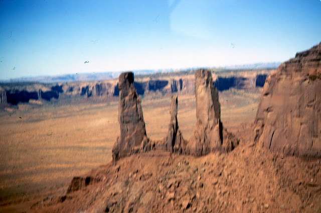
The next six photos with text are about one long fascinating day. We left Albuquerque, crossed the quite invisible continental divide, flew 3 times around Shiprock (sacred to the Navajo and a landmark to the pioneers) for pictures and video, and flew over the Four Corners point , where Utah, Colorado, Arizona, and New Mexico meet. Next on the flight was Monument Valley, where so many cowboy movies were made. Perhaps the biggest thrill of the entire 23 day trip was flying over and between the iconic mesas there.

We landed at Page, Arizona and walked about 3 miles to Glen Canyon Dam, on the Colorado River.


We enjoyed a tour of the big chamber with huge photogenic generators adjacent to the dam.

As we continued flying beside the great river downstream, its canyon deepened and widened. For the first time in flight I experienced vertigo, as we crossed from one side of the widening canyon to the other. We had intended that when we reached the village of Grand Canyon we would fly over the Canyon, but I couldn't do it, because of the sudden fear of height, the perception of all 3 dimensions.
We had planned to hike to the bottom of the Canyon and stay at Phantom Ranch, a simple hostel that is usually fully booked months ahead. However, our Dunkirk NY delay meant we were too late for our reservations, and could only hope for 3 last-minute cancellations. We waited while those ahead in line got their spots, until we finally got ours. It was awesome (again that word, and that feeling), in spite of heat, and carrying only one hat, and my patting an innocuous-looking cactus.

The following day we took flight in marginal weather, dodging snow showers to Prescott, Arizona.
We passed over Hoover (Boulder) dam, and landed after dark at Bermuda Dunes, California. The airport was deserted, but apparently used by the wealthy. We phoned an upscale motel that advertised free transportation, apparently for those arriving in private jets. A limousine arrived, driven by the owner, Lucille Ball's brother. Although he stood by while we checked in, he and the super service vanished when I asked for something cheaper than the initial price. We dressed for dinner, but the restaurant was closed and the transportation had vanished, so we ate crackers and candy from vending machines. Our luxurious rooms had fully stocked bars and patios directly on the Bob Hope golf course.
The next morning we flew below sea level over Salton Sea, an unusual opportunity.

Then we flew up through famously windy San Gorgonio Pass , and landed at Hemet. That was close enough to our friends Dick and Phyllis Plummer in Perris, the congested airspace of Los Angeles, and the Pacific Ocean.
We toured there for 3 days, then headed east along the Mexican border. That cleared strip was clearly visible, as were the deep copper mines in Bisbee, Arizona.

We spent 2 nights in Nogales, from where we drove to a ghost town in the mountains, and to Mexico on their May 5 (Cinco de Mayo) holiday. Near Tucson we were allowed in the mostly-outdoor Arizona-Sonora Desert Museum near closing, to see the iconic tall Saguaro cacti receding on a downward slope towards the horizon. We toured spectacular Carlsbad Caverns, another National Park.
On the 21st day of our 23 we were still in Oklahoma, but woke up early and got aloft just after a dark turbulent cold front passed eastward, and with a strong tail wind made it to Ithaca, New York.
We landed at the Augusta airport on the 23rd day, Sunday. We had logged 55.1 hours, for which we paid $18 an hour, with our gasoline costs reimbursed. Two of those hours were night flights.

 May 29, 2000, a week after all those repair$$ were finished, Marge and I started our trip to Alaska. On board were most of the personal gear we would take on a trip by car from sun to snow, plus the safety equipment required by law and logic in Alaska and northern Canada. That included a rifle borrowed from a friend, ammunition for it, fishing equipment, 2 weeks of dehydrated food for 2, tent, sleeping bags, mosquito netting, saw, knife, stove, more. We included tiedown stakes, tiedown ropes, tools. There was no space or weight allowance left for back seat passengers. Most of that doesn't show in this departure-day picture: this is just the last load.

Our first gasoline-and-pit stop was at Northhampton, Massachusetts. There we happened on Roger Atwood, who had taught me to fly just 50 years earlier. At 79 he was still teaching flying and ferrying planes. He had met Lindbergh, knew Anne Morrow (later Lindbergh), Amelia Earhart, Pancho Barnes, and Howard Hughes. He taught the King of Jordan to fly when Abdullah was a student at nearby Deerfield Academy.

We headed for the "Hudson River Corridor", a tube of allowable airspace for small planes beside Manhattan. The pilot must stay under 1100', stay over the bridges, stay away from the NJ and NY shores. The corridor relies on informal common sense, and is still allowable even after the 9/11 disaster. Marge had been reluctant. It was awesome.

We rode our flying carpet down the river, looking up at skyscrapers, and the World Trade Towers a year before their destruction.

When we arrived at the Statue of Liberty Marge said, "I want to do that again !".

However, we turned right at the Verrezano Narrows bridge and headed for Colorado, where my daughter and family lived. What's this, a wastewater purification labyrinth ?
We landed for the night at Johnstown, PA, site of a famous and disastrous flood a century before.


We left there June 19 for the 300 miles to the Indian village of Northway, Alaska, where we would go through Customs. We couldn't land enroute, because there were no gas stations, and pilots must stick to the flight plans required in Canada. The friendly weatherman predicted headwinds, turbulence and mountain clouds. "Headwinds ?", he said, "It's a law in Canada". Instead we had a tailwind, relatively smooth air, and CAVU (Ceiling And Visibility Unlimited) most of the way.


We filed a flight plan for Chicken , with whose postmaster we had corresponded since we visited there by car from Maine in 1996. Chicken has a short (2500') dirt strip with a sharply rising slope at one end, so we had to land downwind (not good), with the runway out of sight on the base leg, until we turned over the river on short final. Notice the hill that blocked view of the runway on base leg (on left in photo) . Chicken is right of the runway. I radioed, "Chicken Unicom, this is November 3-8-5-0 Victor. What are your winds?" We were amazed by the reply, "I'm at the postoffice. I'll go outside and look". I didn't expect a control tower, but... postoffice...? I replied, "Robin, this is Dick and Marge from Maine". She may have figured that the old couple who said in 1996 that they'd return, never would. We've corresponded ever since.


The weather was deteriorating, and was marginal as we flew over 60 miles of roadless forest to Tok, back on the Highway. That day's Cessna problem was the tail wheel shimmying violently on landing. I fixed that by shortening its control chains. Tok has no municipal, sales, real estate or state income taxes. That leaves Federal income taxes, but some just don't bother with that, we were told.
June 20 we flew to Fairbanks, at 65 degrees latitude our furthest north in a little plane. It was the longest daylight of the year. Since it is a little south of the Arctic Circle it was less bright at midnight, but not by much. The airport had 4 parallel strips: 11800' long for big planes, 3100' long for the hundreds of the mostly taildraggers based there, a long basin for float planes, and a strip for ski planes in the winter. On final for landing we were diverted from the long runway to the 3100' one.
 I had a mechanic change the oil, and watched as he extracted from it a 1" x 14" strip apparently cut from an inner tube. That apparently was used by the Maine mechanic when he was working on the slanted cylinders of the plane. Could that have been disastrous? Yes, the mechanic said, if it had blocked the holes that allow oil to circulate between the cylinders. He showed me the metal gasoline filter, useless because it apparently had been torn long ago. He had a perfect used one and installed it without charge for the the part or labor. I wondered why the Maine mechanic had not replaced the screen. The picture shows pieces of the innertube strip and the damaged filter that was replaced with a good one.
The weather was deteriorating, and was marginal as we flew over 60 miles of roadless forest to Tok, back on the Highway. That day's Cessna problem was the tail wheel shimmying violently on landing. I fixed that by shortening its control chains. Tok has no municipal, sales, real estate or state income taxes. That leaves Federal income taxes, but some just don't bother with that, we were told.
We didn't make any reservations even in this busy tourist season, because we had no schedule. So it was a scramble to find a B&B, way out of town. Like all USA BBs we've used, it was not as good as nearly all the Canadian B&Bs we've used.
We had 3 interesting days there. We went on a river boat tour conducted by 2 cheerful pretty girls, one Indian and one who said she wanted to be the first Eskimo astronaut. We attended a boisterous Solstice fair, where Marge almost lost her pocketbook to an Indian on a bicycle.
We flew south from Fairbanks in view of Mt. McKinley (Denali) through spectacular Windy Pass, famous for living up to its name, to Talkeetna. Its airport is the center for those going to climb Denali, and for sightseeing planes. We had hired one in 1996 to fly around the mountain, and remember one place where I could only say, "Good God", with a lump in my throat, to which the pilot replied, "Everybody says that at this point". There was no plane there then equipped to fly over the top, which we thought would be more beautiful. This time there was such a plane, but it was not more beautiful, because we came to realize it's better to fly near the scenery than over it like an airliner. Nevertheless it was thrilling to look down on the summit, and the climbers' high base camp, and other famous gasp-invoking spots. In 1996 the pilot said as we returned towards Talkeetna, "This seems like a good day to go the Star Wars route", so he descended to the glacier surface, and below, threading his way through a crevasse twice as wide as the plane. We asked about Star Wars this day, and were told, "Nobody does that any more". Understandably.

 We rode 38 miles in their car up through the fog and down to Valdez.
We took the Pipeline Terminus tour the next day. It was conducted by a Maine man who said he planned to retire in Maine with the Alaska-size pension he was earning by plowing Thompson Pass in the long dark winters. He said that with overtime he sometimes earns $3,000 a week. We learned that it has the greatest snowfall (40' average, 78' maximum) of any road kept open all year.
We were disappointed to learn that some of the locals are grateful for the terrible 1989 Exxon Valdez oil spill, because it brought extended permanent facilities and employment to the town to prevent a recurrence. The following day, July 3, B&B guests drove us to our plane, through fog still in pass.
** The third landing wheel was on the "wrong" (for me) end: the front.
** It had a radio. I'd never used one, and was worried about the fast transmissions required.
** The fuel was delivered to the engine by pump, not gravity.
** It was a low winger, not a high winger.
** The flaps were controlled by a hydraulic pump, not by lever action.
** The panel and controls were different.

I took a small mountain of charts and how-to manuals. We hurriedly packed, realizing that our gear would weigh as much, and take as much space as, a fourth passenger. Nevertheless we have a picture of Marge, Phil and I standing by the plane beside the few things we planned to take, including those things we had to leave behind anyway. That first Saturday we reached Dunkirk, New York, where we were grounded by 3 days of rain. We intended to make lemonade out of lemons, so found interesting things to do in that wet drab city with warning signs on its polluted Lake Ontario beaches. At that rate we'd never reach California.
We used the entire runway and then more at an Ohio airport. Here's the end of our landing run.

But the weather improved, and so did our adventure. In Arkansas one of us suddenly required a pit stop. I made a quick map search and calculation, and we landed on the grass strip at Gaston's, a fishing Mecca. As the wheels touched we abruptly discovered that the 6" green grass concealed a 2" deep mixture of water and recent grass clippings, which created giant twin green sprays until we slowed down. I wasn't sure we could safely take off in those conditions and get over the high cliff over which we had just descended. So Marge and Phil stayed behind while I made a test takeoff. That worked fine, so I returned to retrieve them, and we 3 flew onward.
At Oklahoma City we chose the smaller airport, as always, but found too late that it was the busiest, because of its Embry-Riddle Aeronautical University. After we entered the airport pattern in the usual counter-clockwise direction, the controller in the tower told us something that is oft repeated in our family: "One Two Romeo, you are in the pattern backwards - turn right". The great majority of airports have a rectangular pattern that pilots are supposed to follow with left turns, counterclockwise, until they land approximately into the wind. Obviously this airport had a right-turn clockwise pattern. So we left (sic) it as instructed, the controller forgot us, we reminded him, and at last we were on final for landing, under his control. He warned us perhaps 3 times about another plane also somewhere on final, and so warned the other plane. Quite close to landing we found the tower had made and was making a mistake that was almost disastrous. Ours was a low wing plane so we couldn't see directly below, and the other plane had high wings so its pilot couldn't see directly above. Apparently the controller suddenly looked out his tower window instead of at his radar screen, saw the other plane was directly below us, converging vertically at the same forward speed, and ordered its pilot to turn left immediately. Then we saw the other plane, and landed without it.
Eastern Texas has few bodies of water or railroads or other landmarks. That, combined with the unannounced shutdown of a radio station we needed for a navigation fix, and a strong unpredicted cross wind, made our position uncertain as we were flying in Texas. When I climbed 2000' higher so we could receive another station, Phil was as pleased as I when he got us a fix showing exactly where we were. There was bad weather ahead, with possible tornadoes, but we were able to divert directly to a little emergency strip at McLain, Texas. It was getting very dark, except for brilliant lights in a big arrangement of pipes nearby that we learned was a natural gas processing facility. We walked toward and around it, wary of heat-seeking rattlesnakes. Beyond and below it were a few houses we hadn't seen from our tiedown. Here was another example of the generosity we've found when traveling away from cities, by plane or boat or car. The owner drove us 6 miles to the "best motel in town" in his Cadillac, waited while we registered, took us to a restaurant, and took us back to the motel after supper. In the morning he and friends arrived for breakfast and drove us to the airport.
The next six photos with text are about one long fascinating day. We left Albuquerque, crossed the quite invisible continental divide, flew 3 times around Shiprock (sacred to the Navajo and a landmark to the pioneers) for pictures and video, and flew over the Four Corners point , where Utah, Colorado, Arizona, and New Mexico meet. Next on the flight was Monument Valley, where so many cowboy movies were made. Perhaps the biggest thrill of the entire 23 day trip was flying over and between the iconic mesas there.


We landed at Page, Arizona and walked about 3 miles to Glen Canyon Dam, on the Colorado River.


We enjoyed a tour of the big chamber with huge photogenic generators adjacent to the dam.

As we continued flying beside the great river downstream, its canyon deepened and widened. For the first time in flight I experienced vertigo, as we crossed from one side of the widening canyon to the other. We had intended that when we reached the village of Grand Canyon we would fly over the Canyon, but I couldn't do it, because of the sudden fear of height, the perception of all 3 dimensions.
We had planned to hike to the bottom of the Canyon and stay at Phantom Ranch, a simple hostel that is usually fully booked months ahead. However, our Dunkirk NY delay meant we were too late for our reservations, and could only hope for 3 last-minute cancellations. We waited while those ahead in line got their spots, until we finally got ours. It was awesome (again that word, and that feeling), in spite of heat, and carrying only one hat, and my patting an innocuous-looking cactus.
That night it snowed up on the canyon rim. In the morning we photographed the snowdrift that came in around the door. The cabin was austere, but we thought it a better deal than expensive El Tovar, which had a mere curtain to separate the "rooms" (ours and Phil's), and plumbing that Teddy Roosevelt must have used when he visited. We drove a rented car along the canyon rim, and ran out of gas, though we had been told the tank was nearly full. We were privileged to meet and talk briefly with Emery Kolb , an almost legendary figure. In 1903, 16 years before Grand Canyon was a National Park, he and his late brother started the photographic studio on the canyon rim that he was still running. Ken Burns' recent TV series on our National Parks featured the brothers and their daring trip down the Colorado in 1911, recording the first motion pictures of the canyon. Mr. Kolb autographed his book for us.

The following day we took flight in marginal weather, dodging snow showers to Prescott, Arizona.
We passed over Hoover (Boulder) dam, and landed after dark at Bermuda Dunes, California. The airport was deserted, but apparently used by the wealthy. We phoned an upscale motel that advertised free transportation, apparently for those arriving in private jets. A limousine arrived, driven by the owner, Lucille Ball's brother. Although he stood by while we checked in, he and the super service vanished when I asked for something cheaper than the initial price. We dressed for dinner, but the restaurant was closed and the transportation had vanished, so we ate crackers and candy from vending machines. Our luxurious rooms had fully stocked bars and patios directly on the Bob Hope golf course.
The next morning we flew below sea level over Salton Sea, an unusual opportunity.

Then we flew up through famously windy San Gorgonio Pass , and landed at Hemet. That was close enough to our friends Dick and Phyllis Plummer in Perris, the congested airspace of Los Angeles, and the Pacific Ocean.
We toured there for 3 days, then headed east along the Mexican border. That cleared strip was clearly visible, as were the deep copper mines in Bisbee, Arizona.

We spent 2 nights in Nogales, from where we drove to a ghost town in the mountains, and to Mexico on their May 5 (Cinco de Mayo) holiday. Near Tucson we were allowed in the mostly-outdoor Arizona-Sonora Desert Museum near closing, to see the iconic tall Saguaro cacti receding on a downward slope towards the horizon. We toured spectacular Carlsbad Caverns, another National Park.
On the 21st day of our 23 we were still in Oklahoma, but woke up early and got aloft just after a dark turbulent cold front passed eastward, and with a strong tail wind made it to Ithaca, New York.
We landed at the Augusta airport on the 23rd day, Sunday. We had logged 55.1 hours, for which we paid $18 an hour, with our gasoline costs reimbursed. Two of those hours were night flights.
Cessna 172 Sea Planes
Marge and I were sad to see 76A go. It had been an important part of our lives. Then we realized this was an opportunity for a different kind of thrill: float planes. Three months after 76A went with its new owner to Minnesota I started training in Cessna 172 float planes at Twitchell's, an old family-run airport in Turner, near Lewiston. A float plane is a versatile compromise, meaning it's an inefficient plane and an inefficient boat. In both functions new skills are necessary, some counter-intuitive. For example, on water a float plane "wants" to weathervane so it points into the wind. If a pilot is taxiing on the water and wants to go downwind, he must first turn the "wrong" way and operate the ailerons in the "wrong" direction. After about 7 hours of instruction, I was ready for flight test certification. My instructor warned me the FAA examiner was tough, with no sense of humor, so I was nervous. The last part of the test was to demonstrate docking, which is safe but quite tricky. One has to judge the wind, aim diagonally for the dock, shut off the motor at just the right time, climb out on the left float, walk a cable from the left to the right float, and, as the plane neatly sidles up to the dock, jump to the dock to gently control and stop the plane. If not done just right, or the breeze changes, the powerless plane may either crash into the dock or come to a halt several feet short of it. Everything went right in the test near the end, when I forgot to leave my distance-vision glasses in the cockpit before I walked the cable, so I slipped on it and fell. Standing mortified in the cold muddy 4' deep water, I called out that maybe I could pass the test another time, but the famously dour examiner was laughing, and said, "If I get wet you flunk, but you got wet and you pass".
Twitchell's is one of the few FBOs in the world that will rent you a float plane after they teach you to fly one. That's mostly because it's easy to flip one upside down when landing or taking off, so insurance costs, and consequently rental costs, are high. At most other such FBOs the only options are to just brag about your rating or to buy a float plane.
Flying floats takes the pilot back to when the air was not congested, radios were not needed, and freedom prevailed. Float flying is beautiful; when one lands on a remote lake without camps and the engine roar ceases, the beauty and peace are never forgotten. Float planes are most common in Canada, and states with many lakes, principally Maine, Minnesota and Alaska.
All of my float instruction and solo practice before the examination had been on the "nursery", up and down the wide Androscoggin River, between the bridge and Twitchell's airport. My second flight after the test was distinctly different. I flew with Bob Davis over the ocean to the lake on Isle au Haut. We hiked a few miles before returning to Twitchell's.
Marge and I flew several times to 5-mile-long Rainbow Lake, where for several years we maintained 4 miles of the adjacent Appalachian Trail (AT), and where the only buildings were a grandfathered retreat for Webber Oil executives. Its caretakers became our long term friends. I flew there twice to maintain our section of AT, once with Bob Davis and once with a hiker named Amy. I flew twice to remove or bury a dump beside another stretch of AT, made several decades ago when hiker ethics didn't include "Carry In, Carry Out". Once my co-pilot and fellow dump picker was Bob Davis and once it was Alan Lukas.
After our last float flight, in June 1998, Marge and I didn't fly a small plane again for nearly 2 years.
Among other things, we kept busy for that time with these:
* My heart valve operation in 1998.
* Finishing my last 440 miles of Appalachian Trail, with Marge providing taxi service.
* Coping with the FAA. It requires that amateur pilots have a medical examination every 2 years. For me the interval was one year because of my prostate cancer surgery in 1996 and heart valve operation in 1998. The FAA doctors, who then earned lots less than those in private practice, said my spine might snap in flight because of the first, or I might drop dead in flight because of the second, which our doctors said was ridiculous. I had to have expensive tests that only the FAA said were necessary, and finally I was told I couldn't fly, period. Other pilots advised that the only way to get my license back was to go to Mecca, meaning FAA headquarters in Oklahoma City. So Marge and I did, on a side trip from visiting family near Denver.
We found the FAA extremely disorganized, with a backlog of several months. Although that building replaced the one that had been destroyed by terrorist Timothy McVeigh in 1995, we entered and wandered around corridors without seeing a single person, until we found the FAA office. We waited while a clerk went to find our file. An hour later she said she couldn't find it, to come back tomorrow. We returned. They had found "both" files, and said we could talk to the doctor in charge immediately. This was a doctor who had to approve medical applications of tens of thousands of pilots, but talked to us as if he could ignore them and the clutter in his office. He said I couldn't fly, then "happened" to find his unmailed hand-written letter that said yes I might, if I had more tests. All this was (1) an amazing lack of security, and (2) a doctor suddenly dealing with me while there were thousands of pilots waiting for him to process theirs. This was costing a lot of taxpayer, insurance company, and our dollars,. But I got to fly again.
Third Cessna 170A, our last plane: 2000-2003
After I'd finished with the heart valve problem and the FAA and the A.T., we began to think about flying to the year 2000 annual convention of 170 owners that was to be held in Alaska. After looking at 170s for sale in several states in 1999, I paid the FBO at Wiscasset Maine to go with me to inspect a 170 near Pittsburgh. It was rough, with tattered inside fabric and many mouse droppings, and needed many repairs, but he approved my buying it. So I bought it for $21,000. Later it turned out that it was much rougher than it looked, so the money I spent in buying a clean airplane was wasted, and before selling it in 2003 we spent nearly another $20,000 on it. The weather was bad, so we left the plane and drove home.

Notice the pistons etc. before and after I sandblasted them.


Our first gasoline-and-pit stop was at Northhampton, Massachusetts. There we happened on Roger Atwood, who had taught me to fly just 50 years earlier. At 79 he was still teaching flying and ferrying planes. He had met Lindbergh, knew Anne Morrow (later Lindbergh), Amelia Earhart, Pancho Barnes, and Howard Hughes. He taught the King of Jordan to fly when Abdullah was a student at nearby Deerfield Academy.

We headed for the "Hudson River Corridor", a tube of allowable airspace for small planes beside Manhattan. The pilot must stay under 1100', stay over the bridges, stay away from the NJ and NY shores. The corridor relies on informal common sense, and is still allowable even after the 9/11 disaster. Marge had been reluctant. It was awesome.

We rode our flying carpet down the river, looking up at skyscrapers, and the World Trade Towers a year before their destruction.

When we arrived at the Statue of Liberty Marge said, "I want to do that again !".

However, we turned right at the Verrezano Narrows bridge and headed for Colorado, where my daughter and family lived. What's this, a wastewater purification labyrinth ?
We landed for the night at Johnstown, PA, site of a famous and disastrous flood a century before.
May 30: This second day of the trip did not go well. My cold was worse. When I made the initial ground check of the engine I found a few strands of grass, which led to a bird nest built the previous night, which would have caught fire in flight had I not removed it. We flew to Parkersburg in the West Virginia panhandle, where we found unpleasant controllers and ground personnel, and incompetent mechanics. The rear tire noisily went flat on landing. and was "fixed" for $30. The battery was dead after lunch, so I had to hand-prop the engine. That's difficult and hazardous, and was to be repeated often on the trip. Asked for help, the mechanics just stared at the engine. I suggested a new fuse. They inserted one too small, unsuccessfully, and went off to phone about expensive repairs. I found and installed a proper fuse, hand-propped the engine and we continued onward. When the wonderful new GPS started to fail in flight, I found in flight another fuse the mechanics had left uninstalled, so I immediately installed it to fix that problem. At our motel in Louisville we ate the worst restaurant supper I could remember since that English bus stop. The day temperature peaked at 92 degrees.
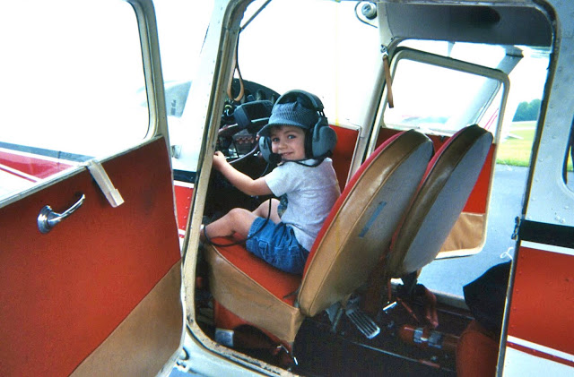

By coincidence Marge's son Phil, his wife Anne, and son Danny were visiting Louisville. Danny got a kick out of "flying " the plane. How time flies. Danny now has a PhD in Maryland.

Third day: On taxiing for takeoff the rear tire was flat again. For $80 the plane was towed to the hangar and a new tire installed.
We made about our longest hop ever, 400 miles to Booneville, Missouri. We put 32 gallons in our 37 gallon tanks !! The little FBO was friendly, the auto gas was cheap, and we took their courtesy clunker to a motel. Most airports we used had a free courtesy car, a vehicle somewhat shabbier than those on inhabited Maine islands. Next morning one of the car tires was flat.
Fourth day, June 1: Strong headwinds reduced our ground speed to 79 mph, per the GPS. Cars on the Interstate beneath us were passing us, so we landed early, at Lee's Summit, MO, where the very friendly FBO let us use their special power equipment to wash off 4 days of grime from our plane.


President Truman's desk, where the buck stopped.
The ground was rising ever higher as we crossed Kansas and approached Denver. Our GPS was extremely helpful in traversing the complicated 3-dimensional airspace restrictions around the sprawling city. The screen displayed a colored moving map showing our plane in precise relation to our planned route and the many prohibited flight areas around that city. We buzzed the home of daughter Carol and family in suburban Erie at minimum legal altitude, but they didn't hear us, so we landed and phoned them.
After 4 1/2 days in Erie it was time to go northward. We planned to start early before heat built up for our takeoff at 5000'+ altitude, but were delayed over an hour, so it got pretty hot. A year earlier a small plane took off in similar conditions there, could not climb, and the crash killed all 4 on board. After takeoff I struggled to maintain enough altitude, until after 5 miles I could safely reverse direction to fly northward.

We made about our longest hop ever, 400 miles to Booneville, Missouri. We put 32 gallons in our 37 gallon tanks !! The little FBO was friendly, the auto gas was cheap, and we took their courtesy clunker to a motel. Most airports we used had a free courtesy car, a vehicle somewhat shabbier than those on inhabited Maine islands. Next morning one of the car tires was flat.
Fourth day, June 1: Strong headwinds reduced our ground speed to 79 mph, per the GPS. Cars on the Interstate beneath us were passing us, so we landed early, at Lee's Summit, MO, where the very friendly FBO let us use their special power equipment to wash off 4 days of grime from our plane.

We rented a car and visited Harry Truman's home in Independence, Missouri, a National Monument. There was only one person space left for the tour, but a lady who lived in the area gave up her reservation so we could both go. That's Marge's black pocketbook. We ate too well at the Apple Farm restaurant.

President Truman's desk, where the buck stopped.
The ground was rising ever higher as we crossed Kansas and approached Denver. Our GPS was extremely helpful in traversing the complicated 3-dimensional airspace restrictions around the sprawling city. The screen displayed a colored moving map showing our plane in precise relation to our planned route and the many prohibited flight areas around that city. We buzzed the home of daughter Carol and family in suburban Erie at minimum legal altitude, but they didn't hear us, so we landed and phoned them.
After 4 1/2 days in Erie it was time to go northward. We planned to start early before heat built up for our takeoff at 5000'+ altitude, but were delayed over an hour, so it got pretty hot. A year earlier a small plane took off in similar conditions there, could not climb, and the crash killed all 4 on board. After takeoff I struggled to maintain enough altitude, until after 5 miles I could safely reverse direction to fly northward.

As we followed the Rocky Mountains on our left, the ground under us gradually rose to over 8,000' in the badlands of Wyoming.

We followed I-25 northward for a while. Here "IFR" means "I Follow Interstate".
We landed at the nearly deserted airport in Buffalo, Wyoming. We drove the airport courtesy car to the "downtown" combination car dealership and car rental agency to rent a better car. There was nobody there, so we sat and waited. Then occurred another example of the kindnesses we have found at small airports and small towns. The dealer arrived, said he had no rentals available, "..but you can use that Buick on the lot over there. Just replace the gasoline before you return it. You don't have to bring it here: leave it at the airport tomorrow". So we drove 200 miles around the Big Horn Mountains, and flew onward the next day.
We were flying in a strong crosswind toward what wind maps ( click here) show as the windiest area of North America, around Shelby, Montana. We stayed 3 nights there, while gales continued unabated. We drove a rented car through Glacier National Park. We found coffee in Montana is uniformly weak, we suppose because the pioneers had to stretch their resources and the tradition persists. One day a hailstorm left the summer ground looking like a snowy winter, and made little permanent pockmarks in the aluminum skin of our plane. The FBO assured us that their local winds are different than those over the eastern flatlands. Eastern winds, he said, are turbulent because fast air moves into still air and the conflict causes turbulence. He said Montana winds blow all the time, so the air just flows steadily without much tumbling. We had to believe him if we were ever to leave Shelby, so on the third day we flew to nearby Canada in winds over 30 mph, which increased with altitude.
As we entered the pattern at Lethbridge, Alberta, we understood why the city proudly claims it is the windiest in Canada. To stay in the landing pattern, sometimes the plane pointed about 45 degrees away from the direction it travelled. On the ground I had to run the engine at high speed and hold the rudder full over, to be able to taxi in an approximate straight line. We were able to get to a tiedown only because an airport worker pushed sideways on the rear fuselage as we moved off the taxiway. The next plane to land lit like a seagull, with no forward speed, its wheels not turning on the pavement until its engine was revved up for taxiing. We found we had landed in winds of 35 mph gusting to 45, increasing to 60 soon after. In winds that strong a plane can leave the ground on its own unless it is tied down.
The next day we flew to Rocky Mountain House, dodging IFR conditions. When we returned with the airport courtesy car the next morning, I had to replace a blown-out main fuse in our plane again, and because the battery was flat again, had to hand-prop it on wet pavement, an unpleasant and potentially dangerous action. The engine starts at a relatively slow 1200 rpm (half the 2400 rpm when flying), or 20 rotations per second. With 2 blades, that means one has 1/40 of a second to swing his hands out of the way before they are sliced off. I continued to occasionally replace the main fuse and hand prop the engine, because of things not done by the Maine mechanic that should have been done, after no expense had been spared to make the plane safe for the journey. Note: Propeller tips travel at about the speed of sound, which accounts for their roar.
We spent the next 2 nights at Fort St. John, British Columbia, until the weather improved. We were treated like royalty by the FBO and the Ramada Inn people in that pleasant little town. It's on the Alaska HIghway ("the Highway"), which was crudely built in 1942 and steadily improved ever since. That road is like a 1380 mile emergency landing strip, because car traffic is light, there are no adjacent utility poles, and trees are cut way back on both sides so wild animals won't suddenly appear on the road. However, it's not straight, and pilots take short cuts, like our next hop, to Fort Nelson.
June 16: We left in CAVU (Ceiling And Visibility Unlimited) conditions. The wheat fields and brilliant yellow canola fields had been left behind, replaced by forest broken only by an occasional oil well service road or logging road. I was grateful for our GPS, which supplemented our paper charts. At one point it showed the nearest airport was 70 miles away. The Fort Nelson FBO was as friendly as we had heard. An American flag was flying, and in the tiny restaurant all-homemade food was served by a friendly old lady, who was the entire staff. We took off on the alternate grass runway (easier on tires) and entered the first true total wilderness we had ever seen, stretching to the horizons. We intersected Toad River, followed that to the Grand Canyon of the Liard, and stayed in sight of that river until we reached the Highway again. Meanwhile there was not a single logging road, only corrugated forest with canyons and snowy mountains: astoundingly beautiful conditions enhanced by our adrenaline. The only place for an emergency landing was an occasional sandbar on the mostly turbulent Liard River. When we were near Hell's Canyon and the Rapids of the Damned, names to stir the adrenaline, I smelled gasoline, and looked up to see the front of the headliner dark with fuel. We were in a cubicle in the worst place to be faced with possible fire or fuel exhaustion.
 We landed at Watson Lake, Yukon Territory, and went to the huge hangar built in 1941, before the Highway was started. Its construction was a phenomenal feat of logistics, transporting materials by barge from Seattle to the mouth of the Taku River, then by truck over river ice and an ice road through mountains to Watson Lake. The airport was a key point in the Northwest Staging Route of World War II, by which planes were flown from the USA to Alaska to Siberia to the Russian front in Europe.
The hangar seemed to have lots of bush planes, vintage planes, and modern planes, but no people. In a back room we found 2 mechanics, brothers whose demeanor had earned them the nicknames of Doom and Gloom. Doom went to our plane to assess our problem. After I reluctantly peeled back part of the new headliner, he found that hose clamps fastening two small rubber gasoline-vent hoses to copper pipes were oversize, so were not as tight as they looked. I'd installed them in Maine, under the direction and approval of the mechanic. Turbulence had bounced some gasoline up into those vents, and out through the defective joint. We got a ride to town, where I bought smaller hose clamps, which I installed before our next hop.
Watson Lake is famous for its Sign Post Forest, which now includes the sign we posted in 2004, on our second trip to Alaska by Toyota. I made the sign wrong: the first car trip was by the Toyota Camry we eventually left in Panama, and the second car trip was by Toyota Corolla. In case you go there: the sign is close to the Sign Post Forest office.


We landed at the nearly deserted airport in Buffalo, Wyoming. We drove the airport courtesy car to the "downtown" combination car dealership and car rental agency to rent a better car. There was nobody there, so we sat and waited. Then occurred another example of the kindnesses we have found at small airports and small towns. The dealer arrived, said he had no rentals available, "..but you can use that Buick on the lot over there. Just replace the gasoline before you return it. You don't have to bring it here: leave it at the airport tomorrow". So we drove 200 miles around the Big Horn Mountains, and flew onward the next day.
We were flying in a strong crosswind toward what wind maps ( click here) show as the windiest area of North America, around Shelby, Montana. We stayed 3 nights there, while gales continued unabated. We drove a rented car through Glacier National Park. We found coffee in Montana is uniformly weak, we suppose because the pioneers had to stretch their resources and the tradition persists. One day a hailstorm left the summer ground looking like a snowy winter, and made little permanent pockmarks in the aluminum skin of our plane. The FBO assured us that their local winds are different than those over the eastern flatlands. Eastern winds, he said, are turbulent because fast air moves into still air and the conflict causes turbulence. He said Montana winds blow all the time, so the air just flows steadily without much tumbling. We had to believe him if we were ever to leave Shelby, so on the third day we flew to nearby Canada in winds over 30 mph, which increased with altitude.
As we entered the pattern at Lethbridge, Alberta, we understood why the city proudly claims it is the windiest in Canada. To stay in the landing pattern, sometimes the plane pointed about 45 degrees away from the direction it travelled. On the ground I had to run the engine at high speed and hold the rudder full over, to be able to taxi in an approximate straight line. We were able to get to a tiedown only because an airport worker pushed sideways on the rear fuselage as we moved off the taxiway. The next plane to land lit like a seagull, with no forward speed, its wheels not turning on the pavement until its engine was revved up for taxiing. We found we had landed in winds of 35 mph gusting to 45, increasing to 60 soon after. In winds that strong a plane can leave the ground on its own unless it is tied down.
The next day we flew to Rocky Mountain House, dodging IFR conditions. When we returned with the airport courtesy car the next morning, I had to replace a blown-out main fuse in our plane again, and because the battery was flat again, had to hand-prop it on wet pavement, an unpleasant and potentially dangerous action. The engine starts at a relatively slow 1200 rpm (half the 2400 rpm when flying), or 20 rotations per second. With 2 blades, that means one has 1/40 of a second to swing his hands out of the way before they are sliced off. I continued to occasionally replace the main fuse and hand prop the engine, because of things not done by the Maine mechanic that should have been done, after no expense had been spared to make the plane safe for the journey. Note: Propeller tips travel at about the speed of sound, which accounts for their roar.
We spent the next 2 nights at Fort St. John, British Columbia, until the weather improved. We were treated like royalty by the FBO and the Ramada Inn people in that pleasant little town. It's on the Alaska HIghway ("the Highway"), which was crudely built in 1942 and steadily improved ever since. That road is like a 1380 mile emergency landing strip, because car traffic is light, there are no adjacent utility poles, and trees are cut way back on both sides so wild animals won't suddenly appear on the road. However, it's not straight, and pilots take short cuts, like our next hop, to Fort Nelson.
June 16: We left in CAVU (Ceiling And Visibility Unlimited) conditions. The wheat fields and brilliant yellow canola fields had been left behind, replaced by forest broken only by an occasional oil well service road or logging road. I was grateful for our GPS, which supplemented our paper charts. At one point it showed the nearest airport was 70 miles away. The Fort Nelson FBO was as friendly as we had heard. An American flag was flying, and in the tiny restaurant all-homemade food was served by a friendly old lady, who was the entire staff. We took off on the alternate grass runway (easier on tires) and entered the first true total wilderness we had ever seen, stretching to the horizons. We intersected Toad River, followed that to the Grand Canyon of the Liard, and stayed in sight of that river until we reached the Highway again. Meanwhile there was not a single logging road, only corrugated forest with canyons and snowy mountains: astoundingly beautiful conditions enhanced by our adrenaline. The only place for an emergency landing was an occasional sandbar on the mostly turbulent Liard River. When we were near Hell's Canyon and the Rapids of the Damned, names to stir the adrenaline, I smelled gasoline, and looked up to see the front of the headliner dark with fuel. We were in a cubicle in the worst place to be faced with possible fire or fuel exhaustion.

The hangar seemed to have lots of bush planes, vintage planes, and modern planes, but no people. In a back room we found 2 mechanics, brothers whose demeanor had earned them the nicknames of Doom and Gloom. Doom went to our plane to assess our problem. After I reluctantly peeled back part of the new headliner, he found that hose clamps fastening two small rubber gasoline-vent hoses to copper pipes were oversize, so were not as tight as they looked. I'd installed them in Maine, under the direction and approval of the mechanic. Turbulence had bounced some gasoline up into those vents, and out through the defective joint. We got a ride to town, where I bought smaller hose clamps, which I installed before our next hop.
Watson Lake is famous for its Sign Post Forest, which now includes the sign we posted in 2004, on our second trip to Alaska by Toyota. I made the sign wrong: the first car trip was by the Toyota Camry we eventually left in Panama, and the second car trip was by Toyota Corolla. In case you go there: the sign is close to the Sign Post Forest office.


In town I accidentally bent my glasses, and went to a garage to borrow pliers to fix them. I got them from a Belgian couple who were having their 1955 Jaguar coupe serviced (#53). It had strange markings, including "Around The World In 80 Days". I have an Amazon book on this entitled "A Lap of the Globe: Behind the Wheel of Vintage Mercedes in the Worlds's Longest Auto Race: (click). Essentials: Forty cars made before 1960 and 4 support vehicles, and their owners who had paid an entrance fee of about $100,000, were on schedule to go around the world in 80 days. So our paths met there. They had driven from Europe across Siberia to Beijing, where the cars flew in the world's biggest cargo plane, a Russian behemoth, and the people flew in a chartered jet, to Anchorage, where they continued down the Highway. We enjoyed supper with the Jaguar owner and his wife.
PS on 4-4-2022: That Antonov plane, the world's biggest in size and carrying capacity, was in Ukraine for servicing, but was destroyed yesterday by Russian invaders.

June 18: Our route from there to Whitehorse, capital of Yukon Territory, was, after much thought, the most stupendous we had flown in our lives. We stayed in sight of the (Alaska) Highway all the way, Visibility was excellent, but several times we went through "virga", which is light snow that evaporates before it reaches the ground.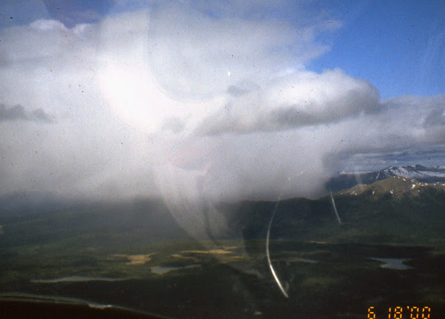


This is the Teslin airstrip at Teslin village on the Alaska Highway on Teslin Lake, 70 miles long. We followed the Highway beside the lake all its length.
The Whitehorse FBO had four $30 rooms for transient pilots, so we rented one which overlooked our Cessna. This was the busiest air hub we had ever used, with jets coming in from all over, and a busy terminal. At its restaurant the waitress heard how we were travelling and said we could use her car the rest of her shift, but we declined with thanks.
We left there June 19 for the 300 miles to the Indian village of Northway, Alaska, where we would go through Customs. We couldn't land enroute, because there were no gas stations, and pilots must stick to the flight plans required in Canada. The friendly weatherman predicted headwinds, turbulence and mountain clouds. "Headwinds ?", he said, "It's a law in Canada". Instead we had a tailwind, relatively smooth air, and CAVU (Ceiling And Visibility Unlimited) most of the way.

The scenery was "utterly utterly awesome" per our flight diary, as we crossed and followed Kluane Lake for nearly 50 miles, with the snow-capped St. Elias Mountains, Canada's highest, rising steeply on our left, its many glaciers stretching out toward us. We stayed at 5000' elevation within 10 miles of the highway. If the motor quit we could glide that far.The navigation was simple: just follow the Highway, here crossed by a glacial outwash.

The yellow area beside the Highway is a mining site. Flight Service warns pilots if there will be blasting, so they can stay at least 3000' aloft to avoid flying stones. Stopped traffic can be another indicator, easily visible from aloft. That's not dependable, because there might be no traffic to stop.

The Highway gradually gets nearer the St. Elias Mountains, which on the Alaska side of the border are a National Park.


The Highway gradually gets nearer the St. Elias Mountains, which on the Alaska side of the border are a National Park.

We had been told the Northway customs agent was one of the most unfriendly of many such USA agents. However, he had been replaced by the exact opposite. He said, "Go relax in the restaurant while I do the paperwork. Ask them to save a piece of their great pie for me".
We filed a flight plan for Chicken , with whose postmaster we had corresponded since we visited there by car from Maine in 1996. Chicken has a short (2500') dirt strip with a sharply rising slope at one end, so we had to land downwind (not good), with the runway out of sight on the base leg, until we turned over the river on short final. Notice the hill that blocked view of the runway on base leg (on left in photo) . Chicken is right of the runway. I radioed, "Chicken Unicom, this is November 3-8-5-0 Victor. What are your winds?" We were amazed by the reply, "I'm at the postoffice. I'll go outside and look". I didn't expect a control tower, but... postoffice...? I replied, "Robin, this is Dick and Marge from Maine". She may have figured that the old couple who said in 1996 that they'd return, never would. We've corresponded ever since.
This is Chicken, population 37, with no phones or indoor plumbing. There in 1996 we had met Robin Hammond, postmaster, who persuasively explained that the post office is the heart of Chicken. She told us that without enough stamp sales the post office would close, and eliminate the year round delivery of supplies by mail, and ski plane when the road is closed by snow. Similarly, some Maine island communities have died when schools close, although in Chicken the few students are home schooled, quite successfully. She said we could buy our stamps from her at no extra cost by using free USPS envelopes she supplied. Ever since we've bought our stamps from Robin in $50 increments. So can you, by writing Postmaster, Chicken AK 99732. Robin and her 2 teenage daughters were travelling in Egypt when we were there on this trip. Her husband is a gold miner.


We walked a half mile to "Beautiful Downtown Chicken", known for its lack of inside plumbing (like Marge grew up with). The friendly bar owner, whose father had been a patient of Marge at Togus, drove us to a woods construction site, where with difficulty we contacted FAA to close our flight plan, so they wouldn't come looking for us. We visited Robin for an hour. She said it was good we'd walked up on the road instead of the shorter path, because the previous week a neighbor had to take refuge in a shed on the path when a grizzly bear threatened.
June 20 we flew to Fairbanks, at 65 degrees latitude our furthest north in a little plane. It was the longest daylight of the year. Since it is a little south of the Arctic Circle it was less bright at midnight, but not by much. The airport had 4 parallel strips: 11800' long for big planes, 3100' long for the hundreds of the mostly taildraggers based there, a long basin for float planes, and a strip for ski planes in the winter. On final for landing we were diverted from the long runway to the 3100' one.

I still have (3/3/23) the strips and damaged filter shown, which the mechanic obviously missed and could have caused a disaster on our wilderness flight.
The weather was deteriorating, and was marginal as we flew over 60 miles of roadless forest to Tok, back on the Highway. That day's Cessna problem was the tail wheel shimmying violently on landing. I fixed that by shortening its control chains. Tok has no municipal, sales, real estate or state income taxes. That leaves Federal income taxes, but some just don't bother with that, we were told.
We didn't make any reservations even in this busy tourist season, because we had no schedule. So it was a scramble to find a B&B, way out of town. Like all USA BBs we've used, it was not as good as nearly all the Canadian B&Bs we've used.
We had 3 interesting days there. We went on a river boat tour conducted by 2 cheerful pretty girls, one Indian and one who said she wanted to be the first Eskimo astronaut. We attended a boisterous Solstice fair, where Marge almost lost her pocketbook to an Indian on a bicycle.
We flew south from Fairbanks in view of Mt. McKinley (Denali) through spectacular Windy Pass, famous for living up to its name, to Talkeetna. Its airport is the center for those going to climb Denali, and for sightseeing planes. We had hired one in 1996 to fly around the mountain, and remember one place where I could only say, "Good God", with a lump in my throat, to which the pilot replied, "Everybody says that at this point". There was no plane there then equipped to fly over the top, which we thought would be more beautiful. This time there was such a plane, but it was not more beautiful, because we came to realize it's better to fly near the scenery than over it like an airliner. Nevertheless it was thrilling to look down on the summit, and the climbers' high base camp, and other famous gasp-invoking spots. In 1996 the pilot said as we returned towards Talkeetna, "This seems like a good day to go the Star Wars route", so he descended to the glacier surface, and below, threading his way through a crevasse twice as wide as the plane. We asked about Star Wars this day, and were told, "Nobody does that any more". Understandably.

The orange-white N3206 plane behind ours is being loaded with gear and people to be flown to Base Camp on Denali (Mt. McKinley. That saves the international climbers a much easier but much longer hike from lower altitudes.

We walked a quarter mile through the woods, and down the dirt main street used mainly by walkers and dogs, to our hotel. The next morning most workers were going to the funeral of a chief pilot and 3 rangers who crashed on Denali days earlier. The restaurant workers told us where the food and gear was and to help ourselves, then they left.
There were hundreds of bush planes parked at Merrill, nearly all tail draggers, some with big "tundra tires". The city has grown right up to all sides of this busy airport, so we had to carefully taxi across a street to get to our tiedown place, near several other 170s there for the convention.
This seemed like a good time to fly to Siberia, which is just across from Alaska, as the lady from Wasilla has pointed out. Other small private planes had done that a few years earlier, but locals told us the Russians now want a lot of money and a lot of paperwork to land there, so we abandoned that idea.
 We spent 5 interesting days in Anchorage, including the convention. 250 members attended, but only 23 170s were flown up from the lower 48. There were also 17 170s from Alaska and 2 from Canada. We met and spent the most time with the Pascals, a couple who had left their elegant 170B in Maryland. A Virginia pilot barely edged us out for the distance record, and a 78-year-old with his arm in a sling edged me out for the antiquity record. We particularly enjoyed a 90 minute charter flight with other 170 owners over the wild Kenai glaciers in an old DC-3, with 1950s music, leg room ( ! ), a pretty "stewardess" in a 1950s uniform and a sense of humor, and unlimited champagne.
A Garmin agent who conducted a seminar at the convention was skeptical about troubles we had had with our GPS, but found that it was indeed defective, and replaced it with a new one.
We had intended to fly to the grass strip in "downtown" Eagle, a historic hamlet on the Yukon River beyond Chicken, but Flight Service said the smoke from worsening forest fires made Fairbanks and that wide area all IFR. So we threaded a spectacular twisty route through the Chugach mountains to Gulkana for gasoline etc, then headed for Valdez, the discharge end of the Alaska pipeline. We followed the pipeline and road for 50 miles through a narrow sinuous deep valley. The valley floor kept rising, but the solid overcast did not, so when we rounded a corner just before Thompson Pass, the highest point on the road to Valdez, we found our path blocked where the rising ground ahead met the overcast. It was another scene of awesome beauty, but called for quick action. We'd just passed a short rocky emergency strip. On our left were ski tracks in the snow (left from the "World Extreme Skiing Competition", we were told) and on our right was Worthington Glacier. Just ahead was a space wide enough for a tight U-turn, so we turned back and landed over power lines, with the glacier at the far end. Marge had wondered what we could do down there, but I said I thought it better to be down than up. A car stopped to help before we could drive tie-down stakes between the rocks. (unrepairable photo damage)

The flight from there to Anchorage was not more beautiful than any other, but it was quite complicated. We flew south over a wide valley to the Pacific Ocean, a branch called Knick Arm. We turned hard right to stay in a mile-wide slot between the main highway to Anchorage and the Chugach Mountains to the left. The next 10 minutes, the final 18 miles, were the busiest. We monitored 4 small airports and avoided the military air base on our right. We changed frequency to get Anchorage ATIS (current basic information), then switched to the Merrill tower frequency. We monitored Elmendorf Air Force base a mile from our Merrill Airport destination, and noted that the main airport, just beyond it, had 1 mile visibility in rain. The tower instructed us to "Report over Muldoon intersection". We had no road map, and the air chart didn't show any "Muldoon", but we reported over a busy intersection in the right place. We were grateful that we were cleared to land straight in at this "busiest general aviation airport in the world", because we didn't want to stay up there. It probably helped that we told the tower, "We've never been here before".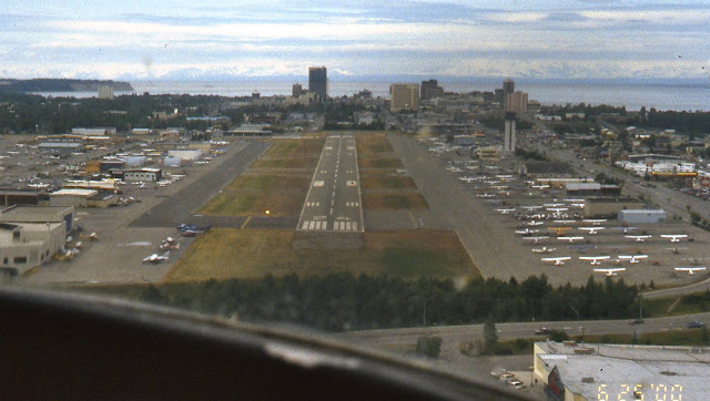

There were hundreds of bush planes parked at Merrill, nearly all tail draggers, some with big "tundra tires". The city has grown right up to all sides of this busy airport, so we had to carefully taxi across a street to get to our tiedown place, near several other 170s there for the convention.
This seemed like a good time to fly to Siberia, which is just across from Alaska, as the lady from Wasilla has pointed out. Other small private planes had done that a few years earlier, but locals told us the Russians now want a lot of money and a lot of paperwork to land there, so we abandoned that idea.

A Garmin agent who conducted a seminar at the convention was skeptical about troubles we had had with our GPS, but found that it was indeed defective, and replaced it with a new one.
We had intended to fly to the grass strip in "downtown" Eagle, a historic hamlet on the Yukon River beyond Chicken, but Flight Service said the smoke from worsening forest fires made Fairbanks and that wide area all IFR. So we threaded a spectacular twisty route through the Chugach mountains to Gulkana for gasoline etc, then headed for Valdez, the discharge end of the Alaska pipeline. We followed the pipeline and road for 50 miles through a narrow sinuous deep valley. The valley floor kept rising, but the solid overcast did not, so when we rounded a corner just before Thompson Pass, the highest point on the road to Valdez, we found our path blocked where the rising ground ahead met the overcast. It was another scene of awesome beauty, but called for quick action. We'd just passed a short rocky emergency strip. On our left were ski tracks in the snow (left from the "World Extreme Skiing Competition", we were told) and on our right was Worthington Glacier. Just ahead was a space wide enough for a tight U-turn, so we turned back and landed over power lines, with the glacier at the far end. Marge had wondered what we could do down there, but I said I thought it better to be down than up. A car stopped to help before we could drive tie-down stakes between the rocks. (unrepairable photo damage)

We took the Pipeline Terminus tour the next day. It was conducted by a Maine man who said he planned to retire in Maine with the Alaska-size pension he was earning by plowing Thompson Pass in the long dark winters. He said that with overtime he sometimes earns $3,000 a week. We learned that it has the greatest snowfall (40' average, 78' maximum) of any road kept open all year.
We were disappointed to learn that some of the locals are grateful for the terrible 1989 Exxon Valdez oil spill, because it brought extended permanent facilities and employment to the town to prevent a recurrence. The following day, July 3, B&B guests drove us to our plane, through fog still in pass.
Here is where I wanted to return to the USA via The Trench. Fantastic experience, but if we had a very long walk out from crashed plane that could be excruciating for Marge, maybe me. See: click .
So we filed a border crossing flight pan and continued to Whitehorse, Canada, that evening, where the air still looked and smelled smoky. Canadian customs was easy and friendly. It was light at midnight, but from here on daylight would decrease as we left behind us the summer solstice and the north. We stayed in a transient-pilot room at the airport again.
We were told that every day two jets land in Whitehorse, loaded with affluent Germans seeking to buy property. Germany was prospering and the Yukon was not, because of depressed prices for the metals that are its main source of income. Whitehorse has a modern downtown, an excellent museum, and a residential area that looks like that of a prosperous Maryland town. Later, in 2004, we stayed there in what must be the best B&B in the world, custom-built, with a breakfast worthy of Gourmet magazine. We used a half-price coupon for it.
We met many interesting pilots on our trip, like two Englishmen there: a lawyer and an 84-year-old pilot, who had flown their twin-engine Piper Aztec from England to Iceland to Greenland to the Arctic islands to Alaska and Whitehorse. We were all at Flight Service when we were told there were numerous thunderstorms ahead, which grounded us and the lawyer. The older Brit flew onward solo.
July 6: We continued homeward on about the same route we had flown northward. We passed a couple of open mining sites where pilots had been warned to stay 3000' above, to avoid rocks thrown up by blasting. Blocked car traffic at one site indicated they were about to blast. Just before Watson Lake the GPS showed "external power lost", meaning another blown fuse. I tried to replace it in flight, but found the fuses sold us 3 weeks earlier were too thin. At the airport I carefully wound the fuse ends with aluminum foil I bought at Watson Lake, and that worked fine thereafter.
Of course I had to hand-prop the propeller to start the engine again. Not safe! We flew over the Grand Canyon of the Laird again, awesome corrugated wilderness all around, and snowy mountains between us and the Alaska Highway, to Whitecourt, Alberta. Forests and grizzly habitat were behind, and benign agricultural plains lay ahead. We bumped along at 2000' above the ground, then for the first time on the trip climbed on top of scattered clouds. At 7500' we had a 20 mph tailwind, more common now that we were going southeast, later east.
We stayed in Whitecourt 2 nights to await better weather, rest, and do laundry. At Saskatoon, Saskatchewan, names which roll nicely off the tongue, we ate at Taj Mahal, rated the best Indian restaurant in Canada, and at Mykynos, an excellent Greek restaurant. We particularly enjoyed the city's beautiful riverfront parks.
We entered the USA at International Peace Gardens, an unpaved strip. We never learned why the voice on the airport radio was that of a visiting Customs inspector, who gave us contrary wind information, which required a go-around, and rattled off documents he'd want to see and where to park, information I neither needed nor wanted while I was handling the turbulent landing. We satisfied Customs, walked the Gardens, and continued to Rolla, ND. We were at the edge of our map, and the FBO had none for sale, so we photocopied their very obsolete chart and continued with the copy to Bemidji, Minnesota, which had maps for sale.
We had a difficult time at Sault Ste. Marie, Ontario, where Lakes Superior, Michigan and Huron meet, viz.:
* While talking to the tower controller on short final, he said, "It's 8 o'clock and the tower is now closed".
* We taxied to the terminal and were told by the same controller, "Wait in your plane for Customs". I replied, "But I was told before takeoff to get out and phone Customs, because there is none here". Reply: "Oh yes, my error".
* After 20 phone machine replies and silence and "We have no record of you..", I closed with customs, sight unseen.
* A young man arrived and said we'd have to tie the plane down at the other end of the field, behind a security fence and locked gate. We taxied there, tied down, and found the gate unlocked and consequently the spot more vulnerable to thieves, not less.
* We went in the terminal, but this set off an alarm, for which we got a lecture.
* The young man got us a Ramada room, which advertised, "Free shuttle", but I phoned and they said they had no driver.
* Airport taxis offered a flat rate of $20 person each way, so we rented a car. After various fees and taxis, the bill was $84 for a total of 26 miles.
* On takeoff the next morning, we were in position for takeoff as instructed, when the controller said a student would be making a low pass over us. I didn't think that was safe, so to see what was coming I revved the engine to swivel the plane around with one wheel locked. The controller said, "I told you to stay where you are: this is a controlled airport". I told him I had to see for safety.
We followed the Ottawa River, skirting the restricted Chalk River atomic research center, to Pembroke, Ontario. We filed an ADCUS (Advise Customs) flight plan, then flew through the Ottawa control area at 5500', until we had to divert from instructions to skirt a big cloud in our way. We landed at Burlington, Vermont, and had our most difficult of border crossings. We told the young agent about our safety supplies including the rifle, so he stood with folded arms, refusing to help, while we had to empty all the crannies of the plane, which was difficult. He chastised us for not having papers for the gun, which we didn't know were necessary. We have had little to do with guns, and had borrowed the gun from an old man who had no papers on it. We had the impression the agent wished we had not reported the gun, in which case the law would have permitted him to have the plane confiscated permanently.
We had a smooth flight to our Maine airport base. There we found the plane's battery, which had given us so much trouble by not holding a charge, was outdated years ago, according to the codes on its surface. The FBO said we should have known enough to replace it before we left. That was the last straw. We had paid him many thousands of dollars to make our plane as safe as possible for the trip, and he had assured us it was. He often told us he was an expert on all things aeronautical, which should have included battery codes. So we moved N3850V to Lewiston.
We flew 50V two more years, mostly around Maine, except for a great flight over the Bay of Fundy to Halifax and back, with Marge and I in N3850V and Gil and Ernie Pascal in their beautiful Cessna 170B from Maryland.
At the 2003 annual inspection the very able mechanic at the Lewiston FBO found that the engine of N3850V required a complete overhaul. At that point we wanted to sell the plane, but believed it would be particularly hard to sell because it was grounded and couldn't be demonstrated in flight. So we paid about $14,000 for the overhaul, and sold the plane.
I quit flying then, October 2003, because:
* It was costing us too much money. We could continue flying by renting planes, but that's not cheap and is much less flexible than owning, and few taildraggers are rented.
* It was costing society too much money: the medically unnecessary tests that Medicare and insurance covered, the money we otherwise could devote to charity.
* It was costing us too much time, and we wanted to do many other things in our limited remaining years. I was 78.
* The FAA is increasingly hostile to recreational pilots:
Navlog.Org/Medicals (now obsolete: find replacement)
From my first to my last piloting was 53 years, which was more than half the time since the Wright brothers first flew. I'd flown in 7 countries, and flown four round trips across the continent: Maine to Mexico, Mexico, California, Alaska. I had about 1500 hours in my log books, had owned 8 planes and flown 14 different models.
A few weeks later we started driving from Maine towards Ushuaia, the bottom of the hemisphere, reaching it in February 2004, their summer. Click on Dreselly.blogspot.com .
Note links to more adventures inside it.
Subscribe to:
Posts (Atom)